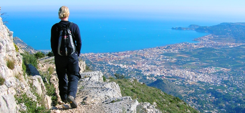
Jávea offers so much more than sea, sun and sangria. From the huge hulking mass of Montgó which extends its protective arm into the sea to the wide open natural spaces of Granadella to the south, the municipality offers plenty of scope for walkers of all ages and all abilities. Five official routes exist, almost 45km of trails opening up the beauty of both the countryside and the coastline and perfect for a brief afternoon saunter along the sea-cliffs or an energetic day-long push to mountain summits. There are gentle strolls winding through the orange groves of the plain or cultural wanders through the narrow streets of the historic centre. There are more energetic wanders to the castle of Granadella or to the iconic windmills of La Plana as well as the amazing carved carverns of Cova Tallada. And there are challenging scrambles to the great open cavity popularly known as the “Eye of Montgó” and, of course, to the very summit of Montgó, standing over 750m above sea level and dominating the town to the north.
There also is plenty to offer within a short drive from the coast, including Aitana, the highest mountain in the region rising to 1,559m, and the enigmatic Barranco del Infierno, a popular hiking destination which is also known as ‘La Catedral del Senderismo’ – the ‘Hiking Cathedral’ – can be explored on the testing PR CV-147, a 15km route that boasts some 6,000 steps carved by the Moorish population that once lived in the area.
So put on those boots, pull on the rucsac, fill the water bottle and get out WALKING IN JAVEA.
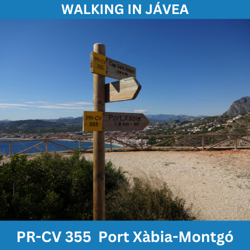
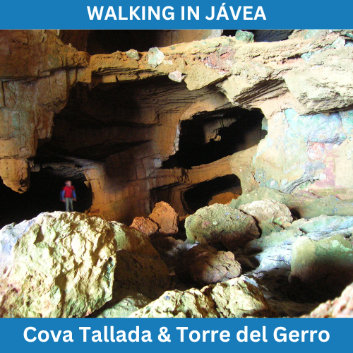
The PR CV-355 is the longest trail in the network, a tough 16 kilometre route from the tip of the Cabo de San Antonio to the top of the mountain of Montgó, taking in the dramatic Cova Tallada – the “carved cave” – and the 16th century watchtower of the Torre del Gerro on the northern flanks of the headland.
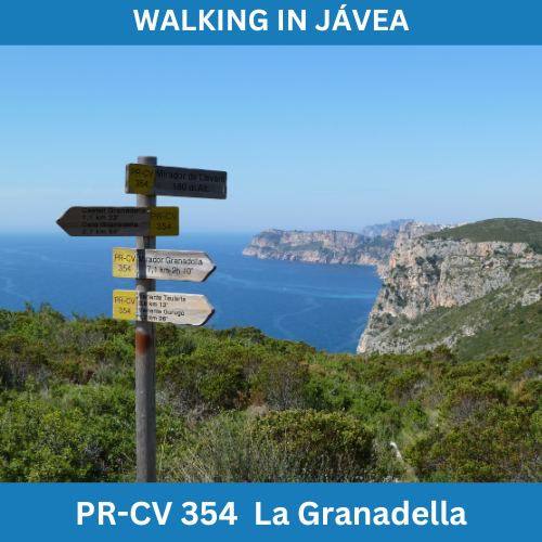
The second longest trail in the network at almost 14 kilometres in length, the PR CV-354 path passes through the undulating hills to the south of the town in an area known as the “Parque Forestal de Granadella”, an area of protected beauty that has often been called the “lungs of the Costa Blanca”.
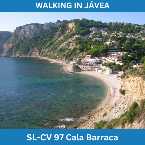
Cala Barraca is a rocky cove situated in the southern half of the bay of Portitxol, guarded on its extremes by the protective booms of Cap Prim and Cap Negre as well as the hulk of the island of Portitxol. This is an easy 1.5 kilometres route from the cross of Portitxol.
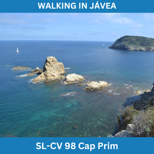
Cap Prim forms the southern barrier of the wide bay of Jávea and affords fantastic views to the north towards the mountain of Montgó and the Cabo de San Antonio. This route is just over two kilometres and is a perfect option for a Sunday afternoon stroll.
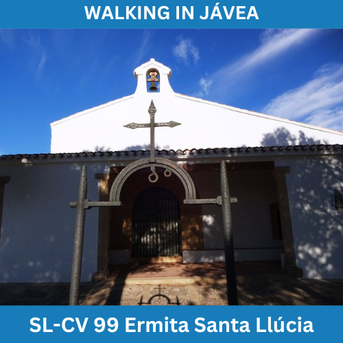
The chapel de Santa Llúcia sits on top the conical hill of Tossal de Santa Llucía, a 165m summit affording spectacular views in almost every direction. This 2.4 kilometres loop starts and finishes in the Plaza de la Constitución and is a perfect option for a Sunday afternoon post-lunch stroll.
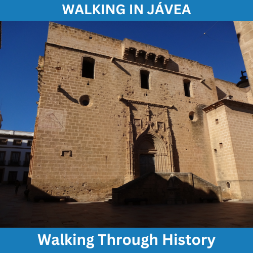
This is a nice walking route around the historic part of Jávea, taking in some of the many iconic locations dotted around this old village, the origin of which can be traced back to the 13th century. There is no start or finish point but it is a simple loop which can be joined at any point along the route.
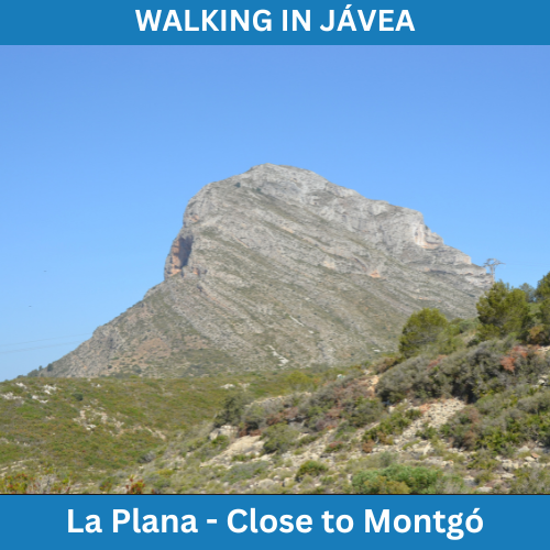
This is a pleasant little route of about four kilometres which proceeds in a large loop around La Plana de Justa, the wide plateau just below the imposing eastern flanks of the mountain of Montgó.
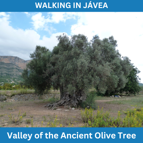
This is an easy five kilometre route through the flat valley of San Bartolomé which visits the ancient olive tree, thought to be between 800 and 1,000 years old and still bearing three types of olive.
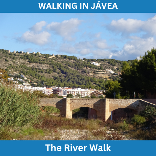
This is a nice flat circular route which mainly follows the course of the river Gorgos from the sea to about three kilometres inland combining both urban and countryside, perfect for an extended morning stroll and perfect for dog-walking.
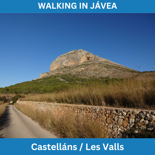
This is an extended nine kilometre circular walk which passes through the zone of Castellans right below the slopes of Montgó and then crosses the valley to the river and then back up through the orange groves to the start.
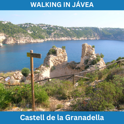
This is a short route to the ruins of the Castell de la Granadella of just three kilometres which might fall into the category of ‘Gentle Stroll’ were it not for two tricky short sections traversed with the use of chains and a steep set of natural ‘steps’ cut into the hillside.
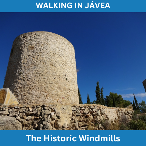
This is a pleasant circular route of some four kilometres via the historic windmills of Jávea, a line of round windmills in various conditions which were built between the 14th and 18th centuries to grind wheat and other cereals grown in the region, and from which there are great views.
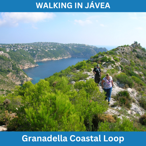
This is a fairly strenuous but very rewarding six kilometre circular route which takes in a short section of the Granadella coast via the castle ruins and Llevant viewpoint and a great ridge walk to reach the plateau of the forestry park itself.
This is a deceptively tough seven kilometre circular route which demands absolute respect. However, it is well within the capability of anyone with a bit of drive and determination as well as a good head for heights. Summer restrictions apply.
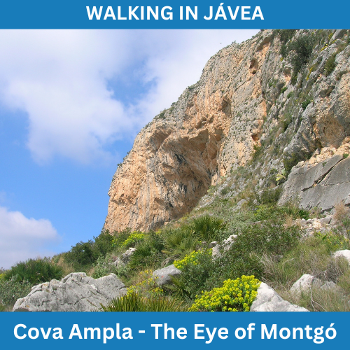
La Cova Ampla del Montgo lies in a huge cavity cut into the southern flank of the mountain of Montgo, a cavern more commonly known as the “Eye of Montgo”. This four kilometre walk is a tough, steep ascent on a path that clings to the mountainside but the effort is suitably rewarded.
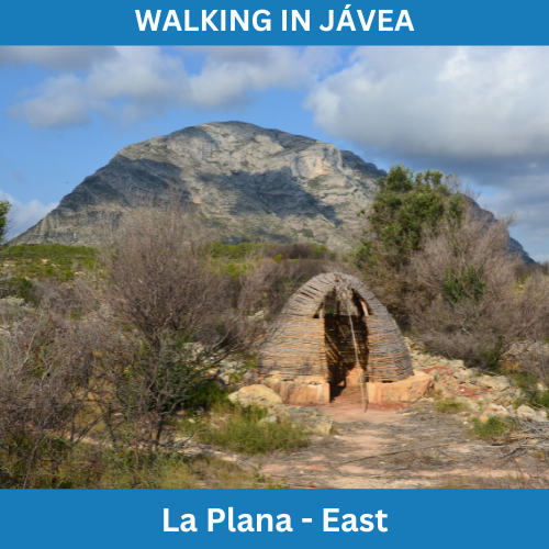
This is a nine kilometre circular route following tracks across the eastern half of La Plana, exploring the northern side of the plateau with its hidden ravines before swinging south through the recreation area to visit the historic windmills and enjoy stunning views over Xàbia and the wide bay towards Cap Prim.
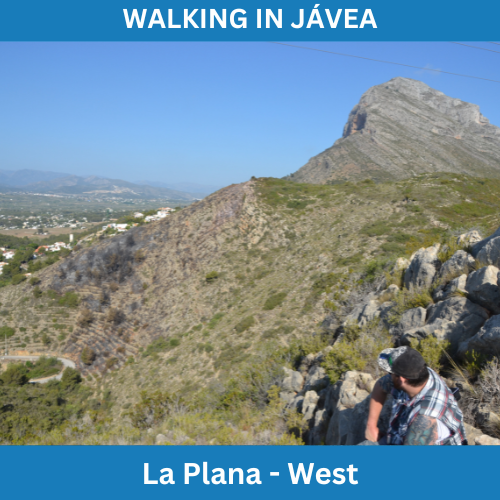
This is a pleasant eleven kilometre walk around the western part of the plateau of La Plana which nudges against the eastern flank of Montgó, visiting the hidden cross marking a macabre history and offering some great views of the mountain, the valley and the sea.
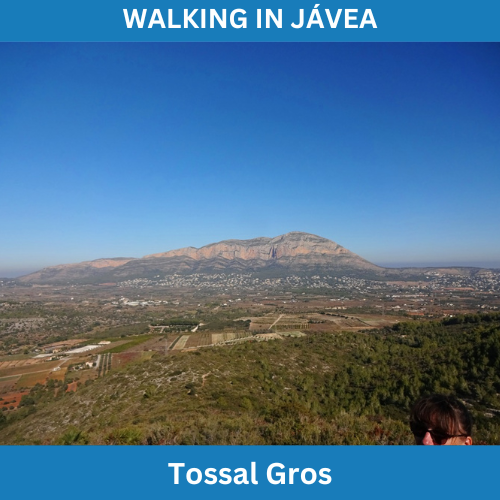
Tossal Gros is a 335m high mound which forms the southern boundary of the wide valley of Xàbia. This whopping 18 kilometre circular route climbs to the top for stunning views over the valley towards Montgó before making its way back to the town through the urbanisations
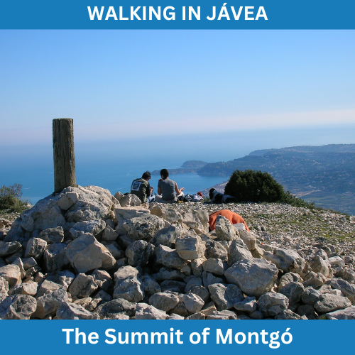
This route describes the simplest way to the top from the flat plateau of La Plana, a steep climb up the eastern face of the mountain by way of a series of zig-zags which carry the narrow but well-trodden path to the bottom of a modest ridge which provides an exciting scramble to the 752m summit.
“Climb if you will, but remember that courage and strength are nought without prudence, and that a momentary negligence may destroy the happiness of a lifetime. Do nothing in haste; look well to each step; and from the beginning think what may be the end.”
EDWARD WHYMPER (1840-1911)
Mountaineer / Explorer / Author