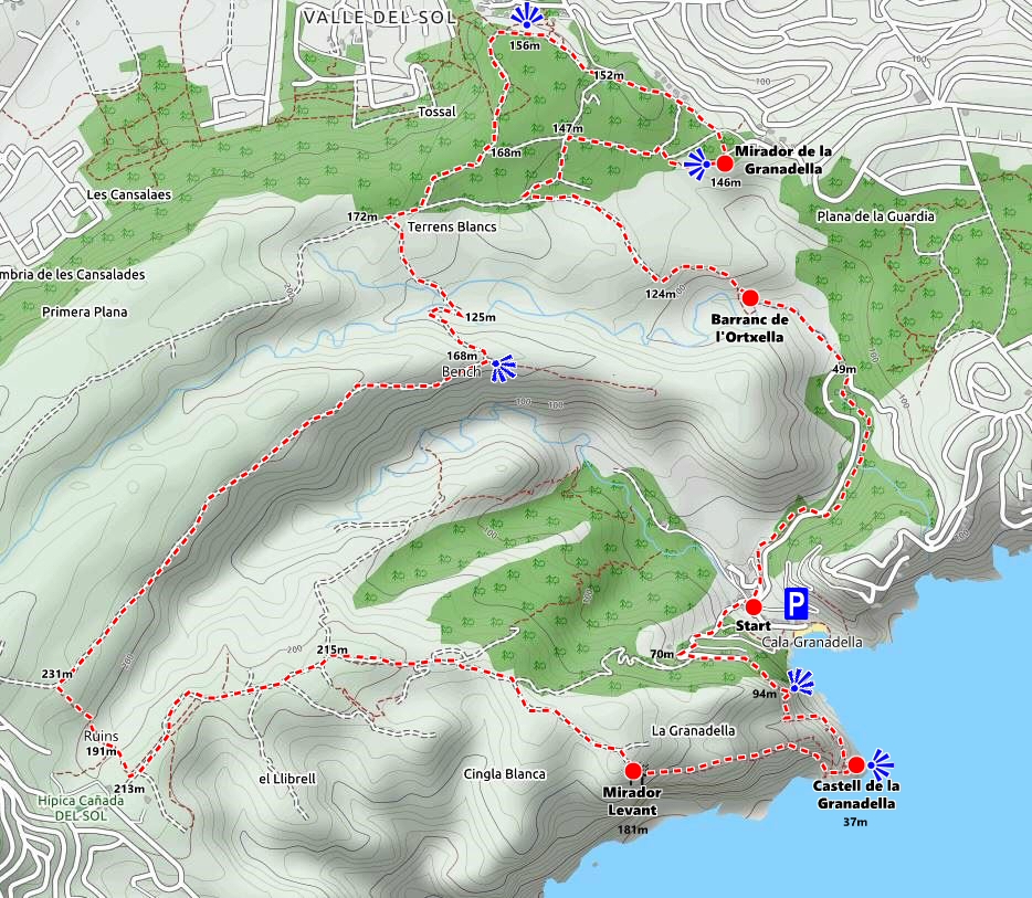
Route Details
- Length: 13,6 kilometres
- Ascent: 1.160 metres
- Time: 4hrs 30mins – 5hrs
- Grade: Medium
- Equipment: Sturdy Footwear, Water, Lunch, Camera
The second longest trail in the network, the PR CV-354 path passes through the undulating hills to the south of the town in an area known as the “Parque Forestal de Granadella“, an area of protected beauty that has often been called the “lungs of the Costa Blanca” but of which much was so savagely destroyed during the inferno of September 2016. However there are clear signs of recovery and it is still a stunning place to walk and enjoy the natural landscape. The route described below begins in the narrow cove of Granadella and passes through several key locations along the coast, including the 18th century watch-tower that used to protect this small bay, and the Mirador Llevant, a stunning viewpoint on the cliff-edge. It can be walked in either direction – in this guide we describe the clockwise direction from Cala de la Granadella.
The start point at the bottom of the Granadella road where the terraced houses start. The river bed is closed to parking due to safety concerns and parking is now available behind these houses up the narrow road of Carrer Pic del Tort.
Be aware that during the high season months of July and August, the road to Granadella cove is closed to vehicular traffic once the parking capacity is reached. There are plans by the local council to restore the shuttle bus service from La Guardia but nothing has yet been confirmed. (March 2024)
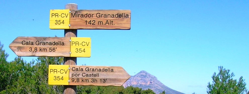
Walking onto the riverbed there is an official route signpost that indicates two directions: for the full circuit, take the left option which is signposted [Castell Granadella].
The concrete road climbs steeply almost immediately and begins to snake its way up the hillside. After some 250m, look out for a painted route marker which shows the way on as the route leaves the tarmac and climbs gently along a wide track until it narrows as its passes to the rear of the row of houses and then veers off to the right to climb up towards the cliffs.
The path edges along the steep drop into the cove below; there is a stunning view of the small cove of Granadella to the left. Eventually the path reaches a small platform area with wooden fencing with splendid views over the bay of Granadella towards the Ambolo headland and the Isla del Descrubidor. The path continues along the edge of a small gorge – you may have to push through the undergrowth – and then drops into the Barranc de la Xapa via a series of very steep steps, both natural and man-made, for which there are now some handy wooden rails to assist in the descent.
The path then pushes through the undergrowth, skirting around the other side of the gorge with the ground dropping steeply away to the left towards the sea. A slip might prove somewhat problematic so two handy chains has been secured along a couple of particularly tricky sections. Whilst keeping an eye on where you are putting your feet, remember to take a look around as a spectacular seascape opens up around you.
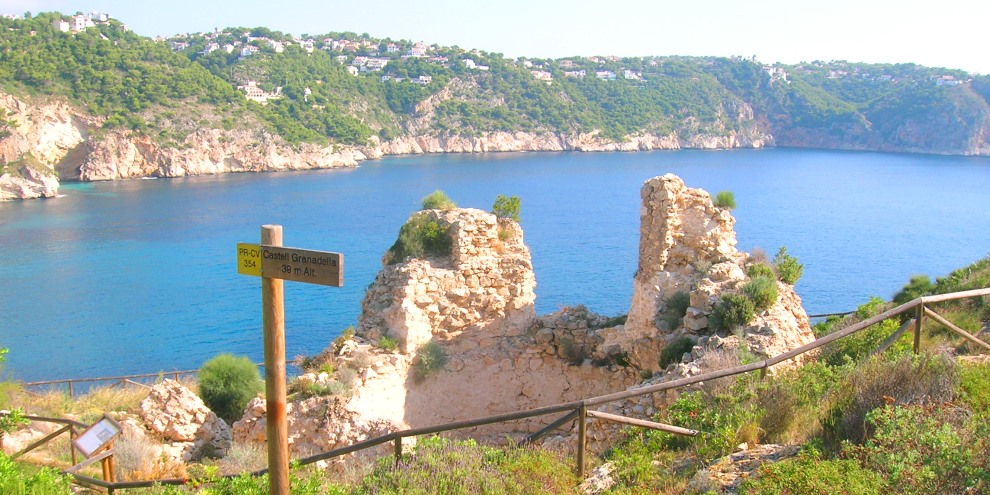
After scaling a low climb, assisted by a chain, the ruins of the Castell de la Granadella appears below you. This small fort was built in the first half of the 18th century and formed part of the extensive defensive system of watchtowers that protected the coast from attacks from Barbary Corsairs. It was the last of such towers to be built and was mostly destroyed during the Peninsular War in the early 19th century.
Signs and subtle painted route markers (yellow and white) lead the way from the castle to the ridge walk that can be quite a tough scramble but affords some fantastic views not only of the bay of Granadella to the north but also the high cliffs that stretch down along the coast towards the headland of Cap d’Or to the south. It becomes a little easier as the path traverses along the top of the ridge and then climbs to the Mirador de Llevant, a great viewing platform some 180m above sea level that provides a perfect rest-stop although there’s little shade from the sun since the roof was torn away a couple of years ago.
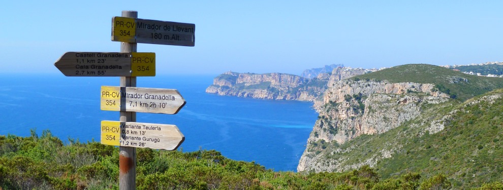
A very distinct path leads away inland. After about 550m, the Teulería variant leads away to the right – suitably signposted – but the route continues onward, rolling across the countryside towards the 439m high Puig de Llorença, the urbanisation of Cumbre del Sol scarring its eastern flanks. After 650m, the Gurugú variant leads back to Granadella, the last option for a short-cut before the nine kilometre loop to Mirador Granadella.
Keep a close eye on the yellow-and-white markers which show the way; after about 700m a small path leads of the main track and then runs alongside it for about 200m before dropping steeply away to the right – marked by a low wooden post – and towards some ruins at the bottom of the Barranc de Martorell which snakes away to the right in between almost vertical cliffs and all the way back down to Granadella.
The path cross along the bottom of the valley and then climbs up the other flank, passing through a couple of ruins before eventually joining another wide track. Turning right, the route follows along the northern edge of the barranc for just over a kilometre, the cove of Granadella beginning to appear again over to the right-hand side. There’s little shade as the sun beats down and almost three hours have passed since leaving Granadella.
When the path turns left, there is a small concrete bench with a great view down towards Granadella and a perfect place to stop and rest for a while. The route turns north – the mountain of Montgó peeks over the ridge ahead – and drops steeply into the Barranc de l’Ortxella. The rough track becomes concrete for a few hundred metres as it descends into the narrow gorge – a hidden valley – before climbing up the other side, not quite as steep as the descent but still requiring plenty of puff.
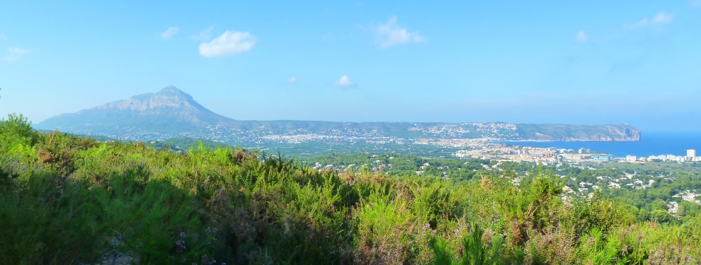
Eventually the path comes across a T-junction and the route turns right. After about 100m, it takes the obvious option to the left and climbs up through what was once a perfect shaded zone but sadly many of the trees were destroyed in the flames of the 2016 inferno. There is some confusion after about 200m when the route markers suggest that the obvious track to the right should be taken. However, despite the suggestion otherwise, the route continues up the slope to open up a fantastic view to the north over the low hills of Rebaldí and Tossalet towards the bay of Jávea and the extended snout of Cabo de San Antonio with the looming hulk of El Montgó keeping guard over the valley.
The route continues along the ridge and it meets concrete once again. A signpost points the way up past a small wooden firetower and after about 350m the route reaches the Mirador Granadella, 142m above sea level and affording some great views over the Granadella forestry park.
The route drops down through what trees remain to the left of the wooden information board behind which the mountain of El Montgó can be seen. The path is steep before levelling out and eventually joining a wider track when the route turns left. A short ascent, more or less the last one, and the route turns left at the crossroads.
After about 200m, look for the route marker painted on a stone on the left which marks the continuation of the route. The wide track eventually becomes narrow, passing through the undergrowth that closes it on all sides. Eventually, at a power line pylon, the path drops over the edge and descends steeply back into the Barranc de l’Ortxella.
At the bottom, follow the dry river bed to the left and, after about 300m, it passes under the CV-7420 road and then passes through the trees for the final stretch back to Granadella, passing under the road once again before eventually emerging back at the car-park.
RELATED LINK: Castell de la Granadella
RELATED LINK: The Granadella Coastal Loop
“The fleeting hour of life of those who love the hills is quickly spent, but the hills are eternal. Always there will be the lonely ridge, the dancing beck, the silent forest; always there will be the exhilaration of the summits. These are for the seeking, and those who seek and find while there is still time will be blessed both in mind and body.”
A W WAINWRIGHT (1907-1991)
The Western Fells