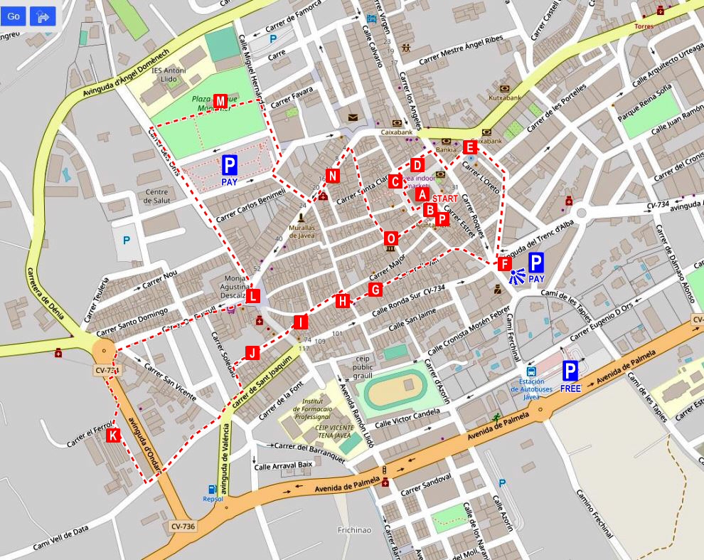
This is a nice walking route around the historic part of Jávea, taking in some of the many iconic locations dotted around this old village, the origin of which can be traced back to the 13th century. There is no start or finish point but it is a simple loop which can be joined at any point which may be most convenient. For the purposes of this description, the route begins right in the centre of town at the old fortress church of San Bartolomé with the town hall and the Tourist Office.
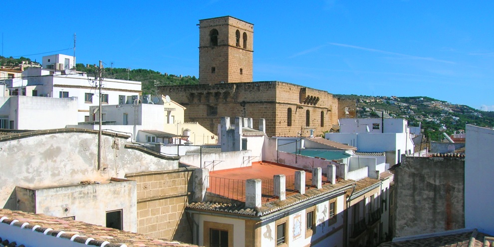
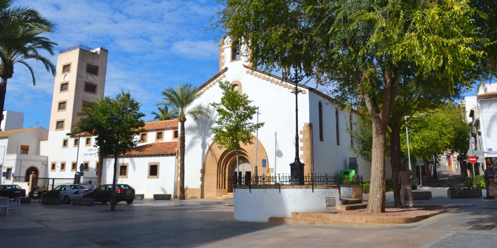
As we stand in the heart of the historic centre, the iconic feature is the imposing Iglesía de San Bartolomé [A] whose origins lay in its fortified tower, dating from the 14th century, next to which an Elizabethan Gothic building was constructed during the 16th century under the direction of Valencian architect Domingo Urteaga. You can still make out the original defensive tower on the eastern (seaward) end of the building with the narrow defensive towers on two corners.
The church met the two needs of the local population: religious worship and defensive protection. It was built entirely out of the local sandstone, known as tosca, which was extracted from the nearby coast and, according to tradition, from the Cova Tallada – the “Carved Cave” – located on the northern flanks of the Cabo de San Antonio. The fortress-like walls are almost devoid of windows, solid and vertical and affording much protection with battlements that run along the top and a number of loopholes.
The two doors have been built in the medieval style with pointed arches and gables and pinnacles. Above each door are machicolations, openings in the battlements through which stones and other items could be dropped on attackers trying to access the building. There is a story that during the Peninsular Wars of the early 19th century, a chaplain located high on top of the bell tower threw rocks onto Napoleonic troops who had marched into the town in 1812. When the soldiers finally managed to access the church, the chaplain himself was flung from the tower. The eastern door has an image of San Bartolomé (Saint Bartholomew) in the tympanum whilst the southern door, dedicated to San Gil (Saint Giles), has a double staircase with a freshwater well. Around the church are the remains of huge cannons which were positioned in watchtowers which once protected the coast. It is said that the larger ones come from the old Castillo de la Fontana that protected the bay of the Arenal, sitting on higher land just behind where Mas y Mas is located now; a high-rise block of apartments – Edificio Castello – is the only reminder.
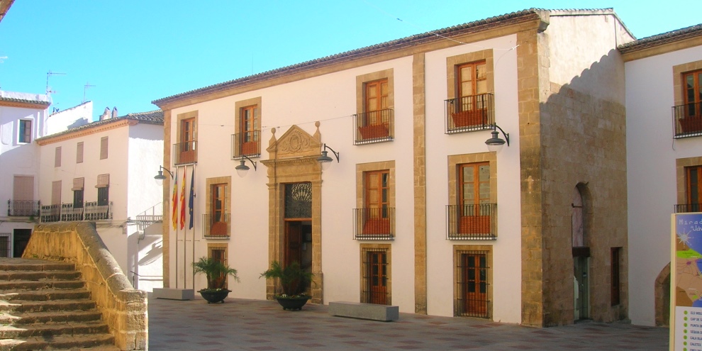
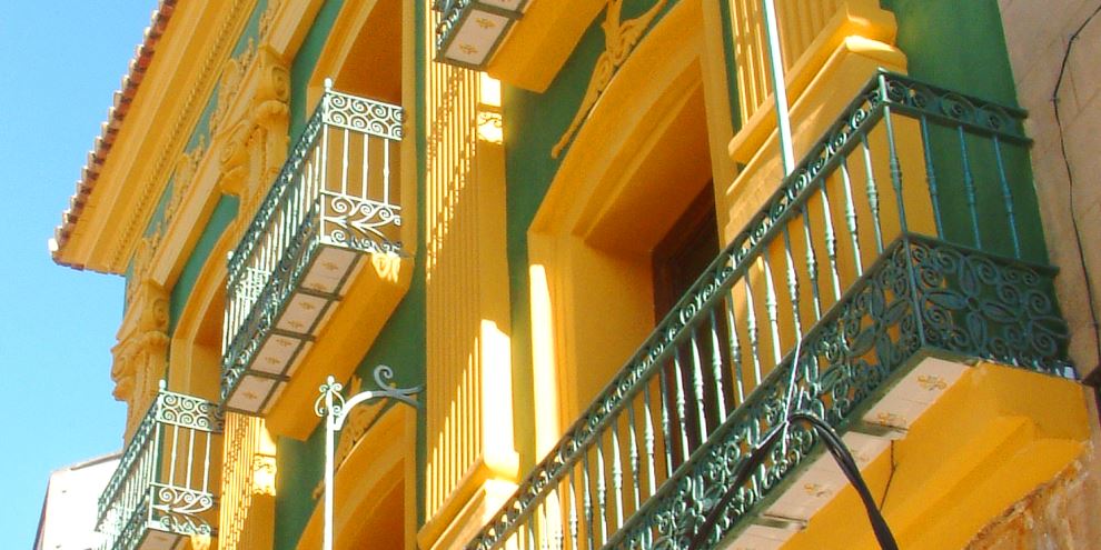
Opposite the San Gil doorway is the 18th century building of the ayuntamiento [B] – the town hall – which was constructed on the site of a chapel called the Ermita de San Cristóbal which itself was built on an old cemetery used during the 14th and 15th centuries. The entrance to the tourist office to the right side close to the archway and steps has a glass floor through which we can see the medieval cemetery.
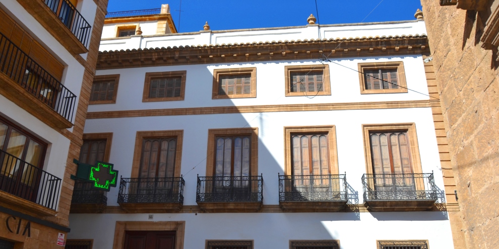
Our route passes by the main door of the church with the image of San Bartolomé in the tympanum, the semi-circular decoration above it, and before us stands the impressive Casa dels Bolufer [C] which is no longer inhabitated on a permanent basis but was once the hub of entertaining in the town with the nobility from across Spain coming to enjoy its comforts. Note the symmetry of the building of which the left side is hidden behind a more recent apartment block suggesting that the square was once much bigger. There are rumours that this iconic house might be renovated and opened again.
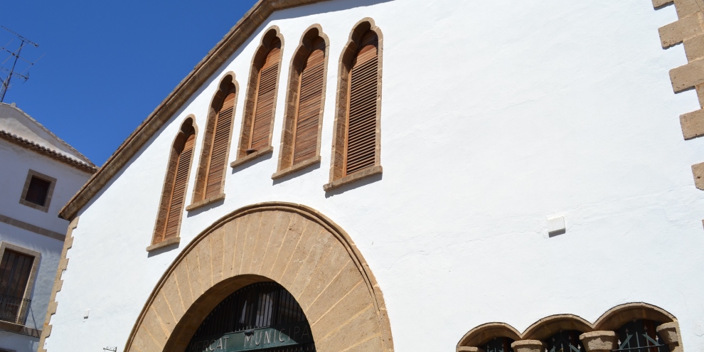
The route passes in front of the western entrance of the Mercado Municipal [D], the municipal market-place with stalls offering everything from bread, fruit and vegetables, meat and seafood. Although it looks as if it might have been standing here for several centuries, the building actually dates from the mid-20th century, built as it was on the site of the Convento de las Agustinas Descalzas which was destroyed during the Spanish Civil War of 1936-39. The original building – its name means ‘Convent of the Barefoot Augustine Nuns’ – was built in the 17th century and contained the body of Sister María Gallard who founded this religious order. She was buried beneath a tall tower from which the nuns could catch a glimpse of the sea. It was said that prior to major events, good or bad, knocking could be heard from her grave; the last time such a noise was heard was just before the convent was destroyed.
After the war, plans were drawn up to build a covered market (the nuns moved to a new convent further down the hill) and the final design reflected the history of the location with its high shuttered windows and round doorways. However not all was swept away in the destruction of the original building and the street which runs along the market’s northern flank is named in honour of Sister María Gallard and it is along this street that our route continues.
Running along the north of the municipal market, Carrer Sor Maria Gallard is occasionally used for games of Valencian pilota when cars are moved away and two teams dressed in blue and red shirts throw a small, hard leather ball at each other. It can be confusing to the outsider with no apparent rules or scoring but spending a few minutes watching the action reveals a game whose origins date back to the 14th century and quite possibly even further.
At the end of the street, look out for an obvious building straight ahead that juts out slightly. You’ll notice that the lower part of the wall is significantly different and it is thought that this is the only remaining part of an ancient wall that used to enclose the small settlement that was growing around the fortified tower during the latter half of the 13th century. The tower itself the Torre de En Cairat which is now protected as municipal heritage and is thought to be the remains of a Moorish farmstead that pre-dates the establishment of Xàbia.
Turning right, we head down the road with the indoor market on our right hand side. When the church comes back into view, you’ll see that the eastern flank is distinctly different from the rest of the church and this is the original defensive tower that existed before the church was tacked onto the western wall. Note that there are few windows and that the corners are fortified with modest square towers; the new bell tower makes the beginning of the new part. Inside the church, there is a noticeable difference in the height of the ceiling between the two buildings.
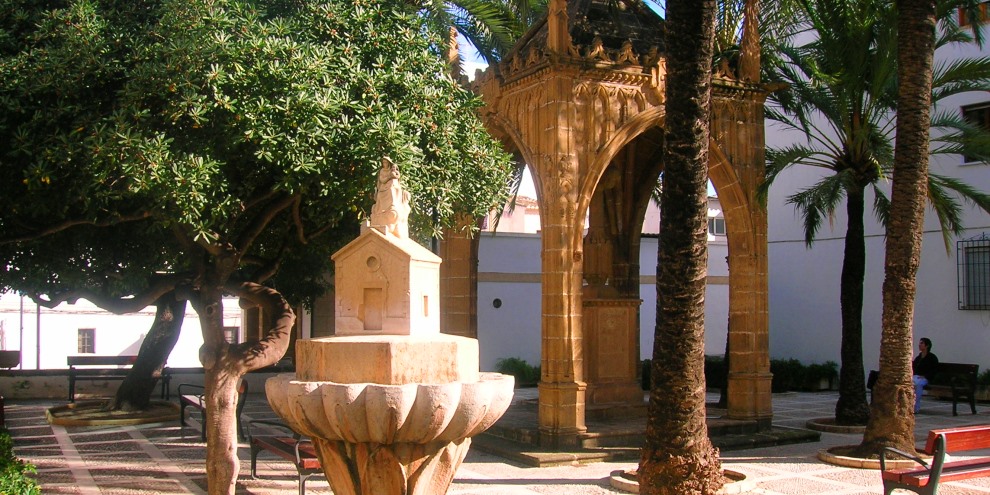
Taking the first left into Calle Escuela, we come across the recently re-named Plaça Vicent de Gràcia [E] on which once stood an old church known as the Església de l’Oreta, a shrine for sailors built in 1515 and demolished in 1870 after the mariners began to migrate down the water’s edge once the danger of piracy had passed and the old walls of the town were pulled down . In the middle of the square is a covered cross built in 1954. There is also a small fountain which reminds us of the former chapel which once stood here.. Both these features were created by master stonemason Vicent de Gràcia and in July 2020 the square was re-named in his honour.
Next to the square is Bar Trinquete, reminding us of its former use as a venue for the traditional game of Valencian pilota, and opposite the bar is a tall stone cross that marks the location of the old gatehouse of Porta del Mar – the “Gate of the Sea” – from which a road ran down to the port area; it’s worth stopping to take a closer look at the cross for it is beautifully carved. And take a look down the wide Avenida del Alicante and on the left-hand side is the car-park of the bar which stands on the site of an old theatre that once stood along this popular avenue for promenading during the 19th century; it seems that you can make out evidence of the graded seating on the far wall. Also in this avenue once stood the British Consulate building as the UK was one of the prime destinations for the raisins produced in the area; indeed, for some time, the British Pound Sterling was the main currency in the town.
We continue with Bar Trinquete on our right, walking downhill. To the right, over a low white wall, we can glimpse an old wall which also once formed part of the old trinquete, an elongated court used for games of Valencian pilota. Some say that it is the only remaining part of the old town walls but it doesn’t seem to fit the dimensions of these defences which were at least a metre thick if not more. Therefore they could simply be remains from the old trinquete. Incidentally, a new trinquete, opened in 2010, is located next to the football ground to the south of the town where there are weekly games of most disciplines of pilota.
The road bends to the right and continues down to Portal del Clot [F]. The presence of another tosca stone cross reminds us that this was the location of another of the gatehouses in the old town walls and the road that left it dropped down to the plain and the fields which provided sustenance for the town. Opposite the cross is a new square from which there are sweeping views to the south over this plain. Clot means “hole in the ground” and until recently there used to be a rough car-park where there is now the Ayuntamiento building, local police station and skate park.
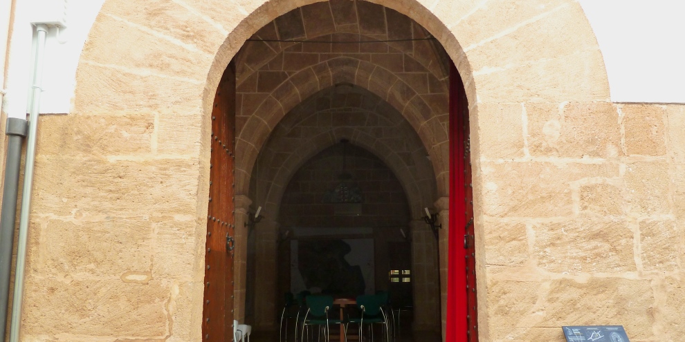
Back at the cross, we pass to its left to climb steeply up the narrow street and then take the first left into Carrer d’Avall, a long street along which we come across the tosca archway entrance to the Capilla de Santa Anna [G], a small chapel which is the only remaining structure of the town’s old hospital which was built in 1502 at the command of Diego de Sandoval, Jávea’s fuedal lord at the time. This was also the site of the second cemetery in Jávea which was laid out at the rear of the chapel. Although it is used primarily as a meeting room by the local council, its stunning vaulted ceiling can be viewed when the chapel is open to the public from 9am to 2pm Monday to Friday.
At the end of the road, we turn right to arrive at a small crossroads, turn left and immediately on our left is the recently-refurbished Casa de Tena [H], now an art gallery (CA Lambert) which was built in 1857 and once used as a pharmacy. The building is rather unique in the town with its columns and painted exterior. We are now in Calle Major and walking on ground once taken by French troops who entered the town during the Spanish War of Independence (1807-1814) and sacked it before driving British troops out of the castle at La Fontana in the Arenal zone.
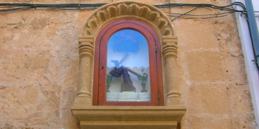
As we wander down the hill, look out for the niche of San Sebastián [I] in the walls on the left-hand side, just where the road forks, the image’s body riddled with arrows. He is regarded as the true patron saint of Jávea, often forgotten after the arrival of the treasured image of Jesús Nazareno but his celebrations have been recently revived by a small band of dedicated devotees. It is thought that he became patron saint during the late Middle Ages when the village was facing the horrors of the ‘Black Death’ which was sweeping through Europe. The terrified people likened the random nature of infection to being shot by an arrow from one of nature’s archers and thus they sought salvation from a saint associated with archers. His niche is positioned close to the location of one of the gates through the ancient town walls, acting as protection against disease entering the village.
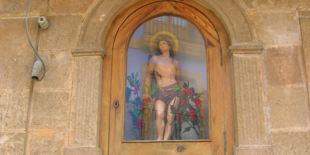
We take the left fork in the road and at the end of the street – the site of one of the gates through the old town walls known as Portal de la Ferrería – we go straight over into Calle Jesús Nazareno [J]. Midway down the road on the right-hand side in the niche of Jesús Nazareno, revered each year in fiesta at the end of April and also during the opening days of the Fogueres de Sant Joan.
At the end of the road, turn left and then right into Calle San Joaquin, a cobbled street was once the original route into Jávea before the wide Avenida Palmela was laid out only a few years ago. Continuing down the road, we reach a wide crossroads; this is where the famous “Nit dels Focs” begins each June. Continue straight on into a narrow street that rises steeply towards Avenida d’Ondara. At the top of the hill, cross the road by the pedestrian crossing and continue straight on with the Silvasol offices to your right. Take the first right into Calle El Ferrol which passes along the rear of those offices with a high white wall on the left.
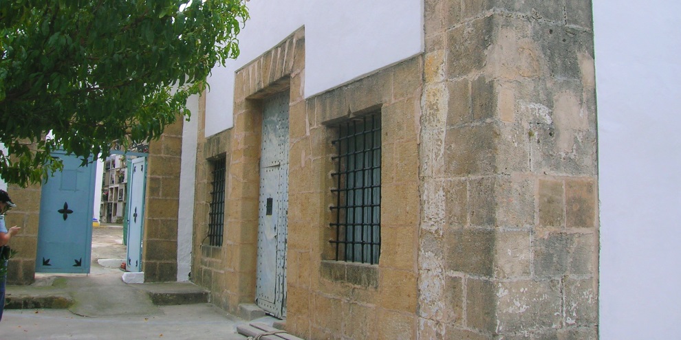
After just a short walk, we arrive at a small square on a rise above the town where there is another small tosca stone cross and the Ermita de Sants Joans [K] and the old cemetery. This chapel was built in the late 15th century or early 16th century and, although access is restricted, there is a small window at the rear (which can be accessed by passing into the cemetery) through which one can see the dozen or so burial pits in the floor. It has been undergoing restoration since 2010 and a number of graves have been found in the floor.
The chapel is actually dedicated to both John the Baptist and John the Evangelist whose feasts are June 24th and December 27th respectively; is it just coincidence that these dates are very close to the summer and winter solstices? Indeed, before the cemetery was built, villagers offered grapes and figs to their revered saint next to chapel and then jumped over fires, a strange eclectic mix of Christian and pre-Christian rituals. This ritual continues today each June as part of the terrific ‘Nit dels Focs’ celebration.
Next to the chapel is the old town cemetery which was opened in 1817. Several high rows of niches exist into which the deceased were placed, the coffins often rolled into place using wine bottles. Around the back of the chapel, there is a curious sloping slab with a groove and a hole; it was here that autopsies were carried out! As the village began to expand, there were concerns about ‘bad air’ being blown into the village by the prevailing winds, this ‘miasma’ spreading diseases such as cholera, chlamydia and even the ‘Black Death’. Although the fears were unfounded after the discovery of germs, the cemetery was finally closed in 1988 and a new cemetery built in the wide valley just a few hundred metres off the Carretera de Gata de Gorgos.
Having walked down the wide staircase, we turn left and then cross the road via the pedestrian crossing to arrive at the olive tree roundabout. It was here that the Fielato was located, a municipal office that collected taxes from merchants wanting to enter the village to sell their goods. It was a very different place then. Three bridges crossed a ravine known as Barranquet de Freginal, now covered up, and the tax office was located at the beginning of what is now Calle Doctor Borrull, collecting taxes on just about everything that was grown in the fields around the village: cereals, olives, grapes and carobs.
Walking against the traffic along Calle Doctor Borrull, the road along which there is an annual bull-running event to mark the festivities of Jesús Nazareno, we arrive in Placeta del Convent [L] – which for many years has been dubbed the “old man’s roundabout” due to the number of seniors who used to sit in the middle and discuss the ways of the world – and we can see the wonderful façade of the chapel of the Convento de los Mínimos which was built in 1946 on the site of an old convent that was destroyed in 1936 during the Spanish civil war. This former monastery was the home of the Order of Minims founded by San Francisco de Paola and today that heritage is acknowledged through the little known celebrations in April which honour San Francisco. The new building hosts a Day Centre for the Elderly, cared for by Augustinian nuns whose order moved from its original location in the centre of town. Note the tower; when the re-located nuns were asked what they wanted at the new site, they requested the building of the tower so that they could catch a glimpse of the sea.
To the right of the chapel, Calle San Juan Bautista climbs steadily up to the huge public open space of Plaza de la Constitución, a huge square underneath which lies the underground car-park. To the north we can see the mountain of El Montgó which is just over 750m above sea level and the much lower Tossal de Sant Llúcia on top of which sits the chapel of the same name. To the left of the square is the music conservatory and the town’s health centre.
We need to climb the wide staircase after crossing the square and then climb a steep path into the trees of Parque Montaner.
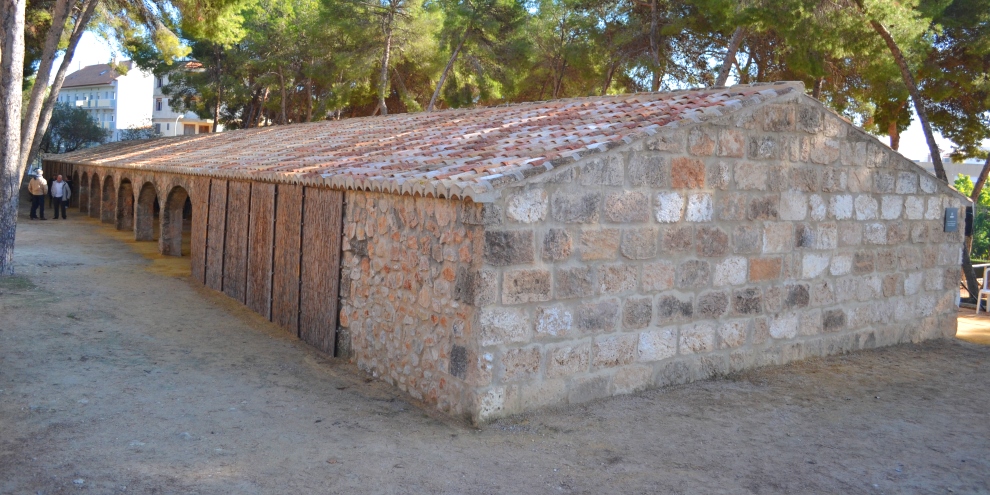
At the crossroads at the top, turn right and we find the Ruirau dels Catalá d’Arnauda [M]. This elongated building, common in the late 19th century, is an almost unique architectural feature of the Marina Alta area and was used to protect grapes from rain and dew as they dried to become raisins. Generally facing south (as this one does), these constructions were often built next to the cottages of the farmer and many can still be seen across the region. The Riurau dels Català D’Arnauda, which was recently moved from its original location close to Avenida Rey Juan Carlos I, is a reminder of the wealth that once poured into Jávea through raisin production which reached its peak in the late 19th century. It is now used for special events and concerts.
Continuing to the end of the path, we turn right to walk back down the hill and back to the Plaza de la Constitución where we cross the square and continue back into the historic centre of town along Carrer Bon Aire. We reach the main road – Avenida Principe de Asturias – a wide avenue which was built in the late 19th century after the town walls were demolished and the town engaged in urban expansion – the “l’Eixample” – to ease the transport of goods from the port to the Placeta del Convent where the main roads from outside converged.
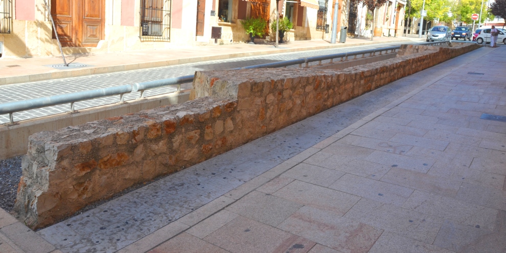
We turn left and walk up the hill. On the right-hand side of the road we find a modern representation of the town walls [N] that used to surround the town for several hundred years until 1874. The low wall remnants were included in the town’s modernisation scheme and have not quite caught the imagination of the local population, having removed valuable parking spaces along the main street.
Close to these walls, at the top of the hill, is the Plaza de la Marina Alta with the offices of ‘Correos’, the Spanish postal service, and once the location of the Portal Nou, the fourth and last gatehouse to be built in the perimeter defences.
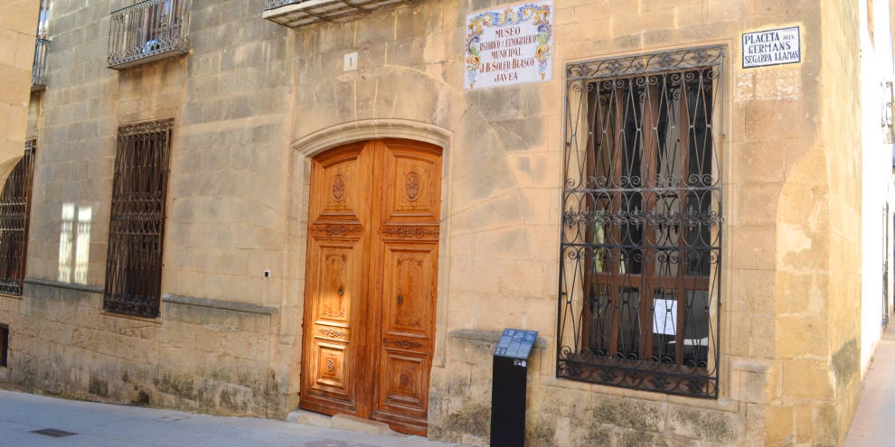
We head back into the centre of the village along Carrer Tossal del Baix which becomes Calle San Isidro and then Calle San Teresa to arrive in the little square known as Plaça dels Germans Segarra [O] which is dominated on one side by the long-abandoned Central Cinema, still begging to be renovated, and on the other side by the impressive Casa-Palau de Antonio Bañuls, built in the 17th century and now home to the town’s Museum of Archaeology and Ethnography.
This huge house was first owned by Antonio Bañuls, butler to King Felipe III and trusted servant of the Marquis of Denia. The story goes that the king was once playing the traditional game of ‘pilota’ and Bañuls was the only man with the courage to tell His Majesty that a shot fell out of bounds by employing some fantastic diplomacy by telling the king that “Your Majesty, you have not committed a fault. It is the ball that has left the court”. He was awarded the house as a gift for his honesty. It was refurbished in the 19th century and then, in 1977, it became home of Jávea’s municipal museum after the efforts of then mayor Juan Bautista Soler Blasco after which the museum is now named.
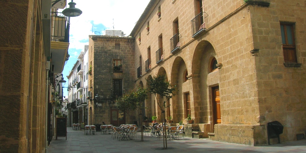
Heading down the slope, we arrive back in Calle Major and we turn left to proceed up the road to Placa del Baix [P], a small but delightful square dominated by the back end of the ayuntamiento building where we can see the five arched porches where there was once an open marketplace; one of the arches is still open and connects by staircase with the Plaça de l’Esglèsia.
At the far end of the square is the comparatively-modern building of the Casa de Cultura which was completed in 2003, constructed on the site of the old Casa del Mayorazgo which once belonged to the Bas family but became the headquarters of the Falange after the Spanish Civil War, the name by which the old building was known until it was demolished to make way for the new building. To the right of the Casa de Cultura, there is the steep narrow road of Carrer l’Estret which is worth a look as it’s famous for its plants and flowers.
Climbing the steps through the archway, we arrive back at our start-point for this route description and hopefully we will have discovered more about the historic centre of Jávea.
RELATED LINK: Visiting Jávea – The Historic Centre
“Living is like tearing through a museum. Not until later do you really start absorbing what you saw, thinking about it, looking it up in a book, and remembering – because you can’t take it in all at once.”
Audrey Hepburn (1929-1993)
Actress