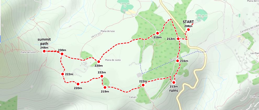
This is a pleasant little route of about four kilometres which proceeds in a large loop around La Plana de Justa, the wide plateau just below the imposing eastern flanks of the mountain of Montgó.
Route Description
Start: Campo de Tiro San Jerónimo (N 38° 48.228, E 0° 09.458)
Length: 4,1 km
Grade: easy stroll
Wikiloc Trail Link (External)
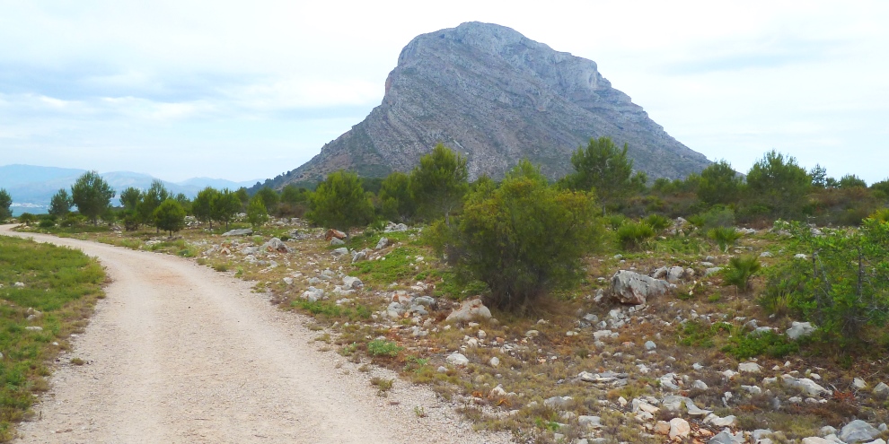
The route is simple and fairly flat, following the wide forestry tracks in a circular route which starts and finishes at the car-park of the shooting range – Campo de Tiro San Jerónimo. The views to the south over the wide plain of Jávea are quite stunning and there is an option to walk to the beginning of the summit path to the top of Montgó from where, on a clear day, one just might make out the island of Ibiza in the far distance, a thin smudge on the horizon to the east. There are no real difficulties, no lung-busting steep ascents, just the tranquility of a natural park which has been protected for over 25 years.
We begin at the car-park of the shooting range (“campo de tiro”) where we can leave the car. Walking back to the road, we turn left and travel down the tarmac for about 50m before taking an obvious entrance to the right. Pass around the red gate and continue towards the trees and the huge bulk of El Montgó ahead of us.
After 60m or so, the track bends to the left but our route goes right through the trees; there are white-and-yellow painted route markers on trees at irregular intervals to guide our way. After 150 metres or so, another wide track is reached and we turn left to follow it past the entrance to the Denia shooting range where there is a large wooden information board which describes the routes and pathways in the area.
After 700m or so, after we have broken out from the trees, the eastern face of El Montgó dominates and the route continues by taking the right fork which is clearly signposted “MONTGÓ” and continues through the high bushes either side before beginning to climb more noticeably for 600m to another large wooden information board which marks the start of the path to the summit of El Montgó. To the east, we can look over the whole plateau down to the lighthouse at Cabo de San Antonio and, on a clear day, we might just spot the thin smudge of the Balearic island of Ibiza on the horizon.
Retracing our steps some 200m, a path leads off to the right – south – and after another 200m, look out for a barely perceptible route marker on the right-hand side of the path which marks the start of the narrow path to the Cova Ampla, the celebrated “eye” of El Montgó. Continue to follow the wide track as it bends to the left and climbs slightly to reach a T-junction. Turn right and follow the track for almost 800m, passing through an obvious crossroads, to where another track leads off to the right. Follow for just a few metres and look out for a narrow track that leads through the trees towards a ruined finca. Just beyond the ruins opens up a fantastic view to the south.
For the final leg back to the car, follow the wide track that leads off to the left when you are facing the wonderful view and it eventually returns to the main track. Turn right and within a few hundred metres the track bends to the right and returns to the main road where we retrace our steps back to the car-park.
RELATED LINK: Visiting Jávea – The Parks
RELATED LINK: Cova Ampla (The Eye of Montgó)
RELATED LINK: The Summit of Montgó