The Mountain
Formed some 70 million years ago, the massif of Montgó forms the last spur of the huge Cordillera Prebética mountain range that runs across southern Spain from Andalucia to the shores of the Mediterranean Sea. It rises to 753m and dominates the skyline for a fair distance. From the south, the light side, it is often said to resemble the head of an elephant with its trunk extending out into the sea.
Route Description
This route describes the simplest way to the top from the flat plateau of La Plana, a steep climb up the eastern face of the mountain by way of a series of zig-zags which carry the narrow but well-trodden path to the bottom of a modest ridge which provides an exciting scramble to the summit. It’s well within the capabilities of everyone with a bit of drive and determination and, of course, with the utmost respect for the mountain.
Route Details
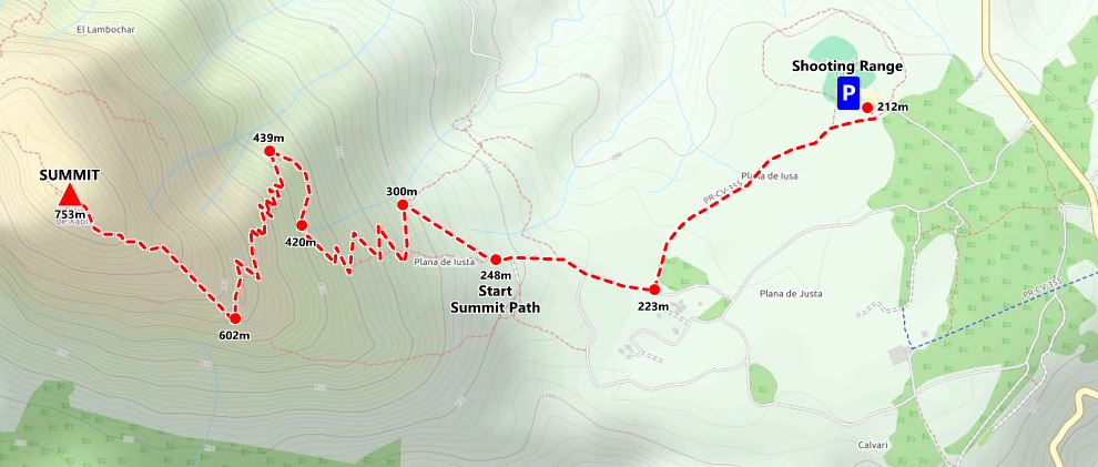
- LENGTH: 8 kilometres round trip
- TERRAIN: forest track and rocky path; some ridge scrambling
- EQUIPMENT: sturdy footwear, snacks, water, camera, wet weather gear (in winter)
- START: Camp de Tiro “Les Planes” Denia (N 38° 48′ 18.9″, E 0° 9′ 5.9″)
The usual access is by car using the CV-736 Javea-to-Denia road and parking is available at Les Planes Campo de Tiro (shooting range) on the Dénia side of the plateau. Be aware that vehicle security cannot be guaranteed by the shooting club and therefore cars should not be left in such a state to be tempting to a potential thief. Incidents are rare but not unknown.
La Plana is crossed by a number of wide forestry tracks which are a pleasure to walk. From the shooting range, walk back down the wide track for just a few metres and a narrow often muddy path will push through the trees on the right-hand side. Continue along this path for 750m as the huge eastern face of Montgó dominates to the view ahead before the path widens and then meets the junction with one of the main forestry tracks.
Here we join the PR-CV 355 official path which started in the Port de Xàbia and has passed through the Cova Tallada and the Torre del Gerro on its way to the summit of Montgó. Turn right towards the mountain and keep straight on when the path divides, a second wide track leading off to the left. The slope becomes a little steep and the track a little more eroded and after 400m or so, it ends where there was once a large wooden sign but now there is a more modest effort.
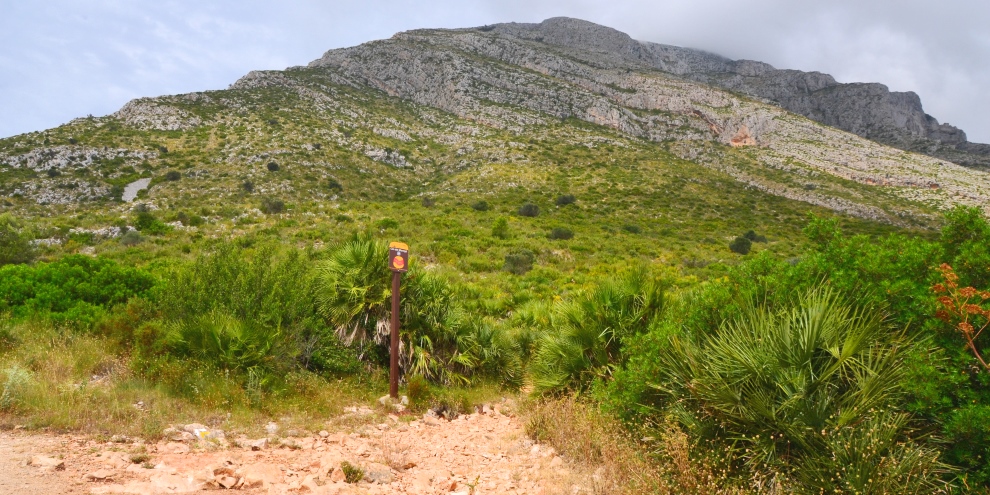
This is a perfect place to take a few moments to study the eastern face of Montgó as it looms ahead of you. You might pick out people already on the narrow path; the Penya Roja is obvious amongst the grey limestone crags and the path passes beneath it.
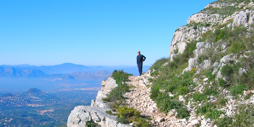
The summit path disappears into the undergrowth and it’s going to get a lot tougher. The ground is very rough underfoot and whilst enjoying the views as the plateau opens up behind you, don’t forget to keep an eye on where you’re placing your feet for there have been many a twisted ankle or a jarred knee taken away as a souvenir of the ascent to the summit of Montgó.
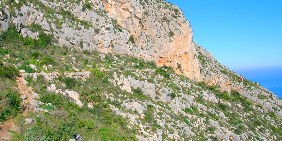
The path zig-zags its way up the mountain in varying degrees of slope, sometimes steeply, other times quite pleasantly as it contours around the face, although you know that there must be more ascent ahead. Once again, resist the temptation to follow one of the ‘paths’ eroded by the feet of irresponsible and seemingly impatient people; instead, enjoy the wonderful views as you climb and take plenty of photographs. The path is quite pleasant as it passes below the Penya Roja, the red crag of rock that serves as a decent place to stop, take in some fuel and admire the view to east, before it begins a steep set of seemingly never-ending zig-zags.
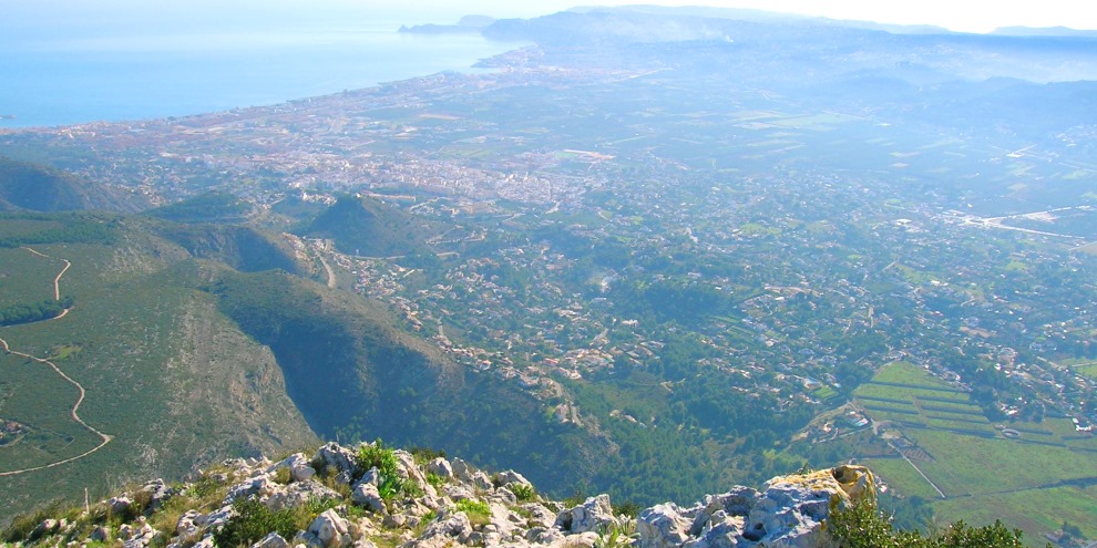
After an hour or so of climbing the path appears to end abruptly at the top of a long drop over the edge of a high cliff with stunning views over Jávea, its wide bay and the fertile plain. Take another breather, admire the views, pick out familiar landmarks and take on some more fuel. For behind you lies the final stretch to the summit which is effectively a ridge scramble over rough rock. There is rarely a discernible path but look out for the white-and-yellow markings painted on rocks at intervals which will assure you that you are on the right track.
At the top of the ridge, a path hugs the cliff as it passes above an almost vertical drop down to the villas below, not one for those with a nervous regard of heights, and with a final scramble through a narrow cut in the rock, the summit is finally reached and a stunning panorama opens up all around you.
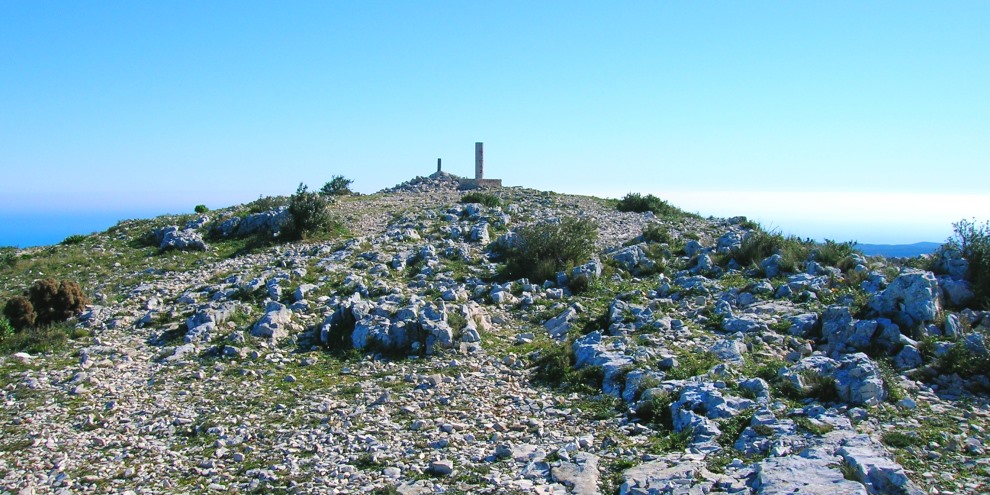
To some, the top might be a little disappointing; a short post kept in place by a pyramid of stones and a touch of concrete marks the actual summit whilst a low graffiti-covered concrete post set on a small concrete plinth is close by; it’s difficult to determine which marks the absolute highest spot. There are plans to restore the huge cross that used to stand here and if you look to the north, you might just see a cross at the end of a long ridge that is often mistaken for the summit from people ascending from the other direction but it is more than 50m lower than the actual summit.
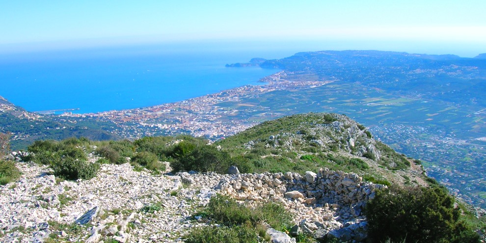
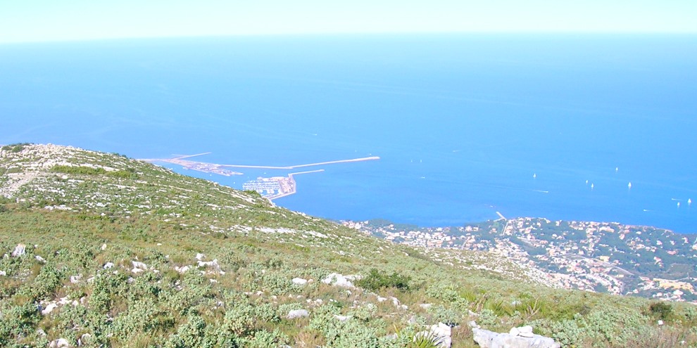
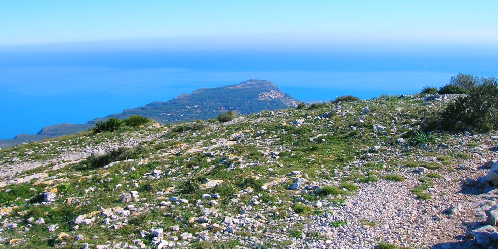
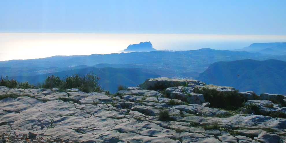
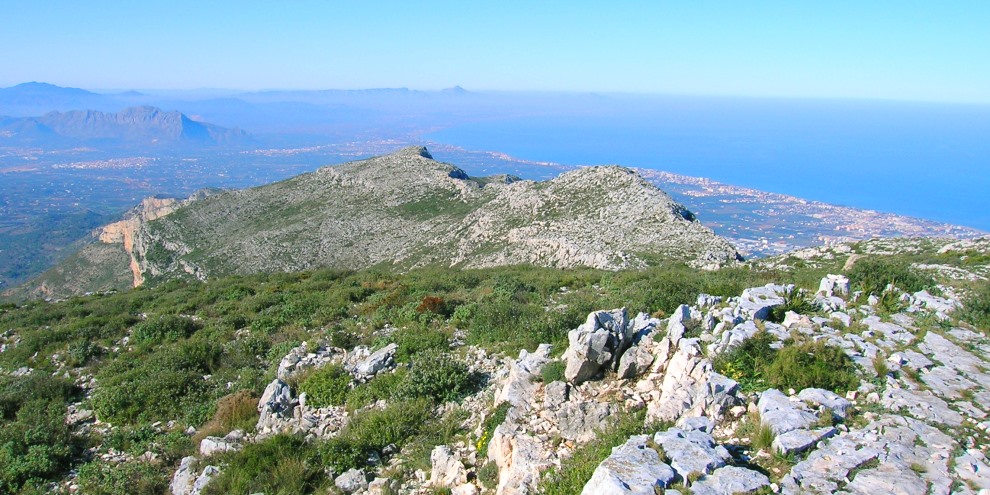
On a clear day, the view is stunning in all directions. To the east, the headland of Cabo de San Antonio points towards the island of Ibiza on the horizon; to the south is the Peñon de Ifach (Calpe Rock), the Sierra Bernia and the Morro de Toix. To the west, the Col de Rates, the Sierra de Aitana and the Val de Laguart; and to the north, the gulf of Oliva and Cullera stretches up towards the city of Valencia.
Take your time to enjoy the experience; too many people charge up to the summit, take a few photos and then disappear back down the path. This could be a once-in-a-lifetime moment; you may not want to ever to do it again but you’ve hauled yourself up to this point and you should darn well enjoy it!
Unless the weather is extremely poor, you won’t be alone on the top. There are two longer routes to the summit which come in from the west; one from Jesús Pobre and one from Denia. Little groups will be sitting around, enjoying the views, having a picnic and maybe a few celebratory glasses of cava or wine. Nods of acknowledgement often turn into long conversations of shared experiences; you’ve all made great efforts to reach this point and the desire to share is almost irresistable.
The return is via the same path that you ascended the mountain and it’s fairly straighforward, although from painful experience extreme care should be taken on the ridge as it’s not much fun to hobble down the remaining two-thirds of the descent. Again, resist the urge to take short-cuts; not only will you be contributing to the destruction of a natural habitat that is almost unique to the mountain but also run the risk of slipping on the steep slopes. When you reach the bottom of the summit path, don’t forget to take a look back – you’ve done it!
And when you next sip a cool beer on the Arenal and stare at the mountain dominating the view to the north, you can take pride in the fact that you’ve climbed it.
RELATED LINK: PR-CV 355 Port Xàbia to Montgó
“It is not the mountain we conquer, but ourselves.”
SIR EDMUND HILLARY (1919-2008)
Mountaineer and Explorer