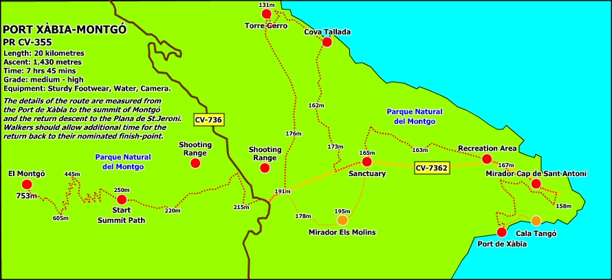
JÁVEA’S OFFICIAL TRAILS – PR-CV 355
The PR CV-355 is the longest trail in the network, a tough 16 kilometre route from the tip of the Cabo de San Antonio to the top of the mountain of Montgó, taking in the dramatic Cova Tallada – the “carved cave” – and the 16th century watchtower of the Torre del Gerro on the northern flanks of the headland. It’s quite common to walk the route in stages and there are a number of shorter options which visit different sections such as Cabo de San Antonio, the windmills of La Plana, Cova Tallada and the Torre del Gerro and the big one itself, the ascent of the mountain of Montgó.
The route begins at the very end of the marina road. There is limited parking – and in any case, one would have to walk back to collect the car at the end of the day if you’re planning to walk the whole route – so the preferred option would be to ask a friend to become the support team who can drop you off at the start-point and then meet you some ten hours later at a suitable rendezvous, such as the shooting range of Campo de Tiro Les Planes close to the bottom of the summit path to the top of the Montgó.
Close to the small roundabout at the end of the road is the Restaurante El Tangó, a delightful, isolated spot overlooking to hidden cove of El Tangó, which is also known as “Pope’s Cove”. There used to be a small beach here in front of the restaurant just a few short years ago but the sea has claimed it and now it’s a rocky, virtually inaccessible place. Two information boards and a wooden signpost mark the start of the path and the opening few metres reflects the reputation of the route; steep and rocky but with stunning views of the small cove, a favourite with divers and bathers who prefer a little solitude.
The path climbs steadily, with occasional scrambles, into a narrow gorge, passing another wooden signpost making the ‘Variante Cala Tangó’, a short stroll along the face of the cliffs to a narrow rock sticking out into the sea which once served as a rescue point for masted boats. Plenty of puff is needed to overcome this opening stretch until the route eventually opens up onto a small ledge on the cliff edge which commands great views over the marina and beyond.
The path winds along the slopes in a steady climb towards the top of the headland. Before the devastating fire of September 2014 the path disappeared into the forest of trees, bringing silence and a feeling of solitude as the noises from the working port were drowned out by the chatter of birds; the canopy also brought temporary relief from the sun and was a perfect spot to take on some water. Sadly the trees were consumed by the fire and the route is exposed for its entire length, although the flames have revealed the old terracing that was built into the side of the slope many years ago.
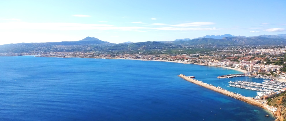
Within the hour, the route eventually emerges onto the top of the Cabo San Antonio and onto a large man-made ledge with stunning views over the bay of Jávea and beyond. This was the site of an old 16th century chapel of San Antonio which gave the headland its name, a place for men and women with profound religious convictions to lead solitary lives of prayer. The chapel was constantly in danger of attack from raiders from the North African coast and a watchtower was built close to the chapel. Both are now gone, demolished to make way for the lighthouse at the end of the 19th century. But there are signs of what once was, including this platform, albeit one that has been renovated in modern times.
The path heads inland to the road and then the route turns left away from the lighthouse and follows the road for some 150m when a wide track leads off to the right to the mirador ‘Cap de San Antoni’, once of the most popular viewpoints in the network, no doubt due to the ease of access by vehicle. At the end of the track, next to the car-park, there is a solitary tree giving shade to a wooden bench and a stone seat; somehow it escaped the flames and still provides a respite from the fierce sun. Behind is the wooden information sign of the viewpoint and the path leads through the rocks behind it (look out for the wooden waymarker painted white-and-yellow on the left). It can be tricky to follow at times but the painted markers have been redone recently and it means that walkers can keep clear of the road along which drivers often rush in their eagerness to get to and from the lighthouse.
The route crosses the road at a clearly defined point and then continues alongside the tarmac to the recreation area of San Antonio, a landscaped set of ledges which are perfect for a picnic of a sunny Sunday afternoon. It is remarkable that much of this fantastic little oasis of calm escaped the ravages of the inferno and there are still shaded areas with benches to rest and enjoy the relative quietness of the plateau. There is also a place to refill bottles with drinking water.
For the wide path continues on the other side of the car-park for about 1½ km. Once again it used to pass through trees, providing some shade and glimpes of the sea through them but now the whole plateau is exposed and the views are clear to see. There are also some positives from the tragedy with the remains of old lime kilns adapted to become points to visit and understand the industry that once thrived in these parts.
At an obvious T-junction, the route turns left, pass the ruins of an old police barracks and, after about 400m, returns to the main road at a point where sits the Santuari Mare de Déu dels Angels, a building which less than 50 years old but sits on the site of a monastery dated back more than 600 years. It’s a perfect setting to relax for a few minutes and take on some much-needed fuel.
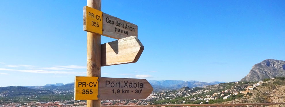
Here the path splits; straight ahead is the mirador of ‘Els Molins’ on the ‘Variante Molins’ route but this long route turns right, following the main road for about 400m before turning right – there is a wooden signpost pointing the way – into Camí de la Plana de Sant Jeroni. The main track loops around houses for about 600m; avoid the temptation to leave this route and if you are unsure of the right route, look out for the white-and-yellow route markers that are painted at various intervals on tree trunks, large boulders and the occasional junction box to guide the way. The track eventually arrives at a path hub, a mass of rough narrow pathways that lead off in several directions. Again, the route is clearly marked by a short post with the familiar white-and-yellow lines weaving across the rough heathland.
The path is clear as it passes through clumps of lavender and dwarf palm but can be quite rough underfoot and, as you around the head of the Barranc de la Foradada, a deep ravine in which evidence of human occupation some 40,000 years ago has been found, the temptation to enjoy the views opening up around you could prove painful. The engaging Lakeland author A.W. Wainwright once warned readers “to avoid accidents and always watch where you are putting your feet” and large rocks poke through the ground, coaxing a twisted knee or a turned ankle so, despite the unveiling of superb views around you, some attention had to be given to avoid an unfortunate mishap.
After about 850m of relatively flat walking, the path disappears abruptly over an edge into the Barranc de la Cova Tallada. After a fairly easy scramble, a long chain assists passage over a particularly difficult section which might test those with an acute fear of heights. But the descent is fairly easy with a bit of encouragement and nerve. At the bottom, the path leads off around a rocky bluff and becomes quite narrow for a few metres alongside a large drop to the left-hand side and care should be taken.
The path descends steeply into the impressive ravine. Again, care should be taken as there is plenty of scope for a sudden slip on the loose surface. After around 250m, the path widens as it finishes its descent and there is a small information board and another PR-CV 355 signpost with more ambitious timings.
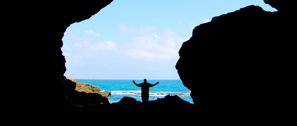
The Cova Tallada lies down to the right and a small wooden sign points the way down a particularly tricky scramble to the water’s edge. Careful footing and strong handholds are needed as you edge around the cliff face before a high opening leads into the Cova Tallada. The size of the cave takes the breath away and makes the effort to reach it all the more worthwhile. At first glance it appears to be an ordinary but sizeable sea-cave but this was an important medieval quarry for the tosca stone that built many local buildings including the castle of Denia, first built by the Moors in the 11th and 12th centuries before being extended and fortified between the 15th and 17th centuries, mainly with stone hewn from the walls of Cova Tallada. The excavation continues deep into the cliff and a torch is needed to explore further into the quarry.
After plenty of exploration, the route now continues along the coast towards the Torre del Gerro which can be seen on the cliff-top some 650m away. After a tricky climb from the information board, the path skirts along the coast – part-walk, part-scramble – for about 500m into Barranc de l’Aiguadonç above which sits the watchtower. Whilst not technically demanding, there are moments when the ground slides away steeply towards the sea and a 20m length of rope has been secured to the rock over a particularly exposed section. Other sections drop into the undergrowth with low branches and protruding roots eager to catch out the occasional passer-by.
After plenty of exploration, the route now continues along the coast towards the Torre del Gerro which can be seen on the cliff-top some 650m away. After a tricky climb from the information board, the path skirts along the coast – part-walk, part-scramble – for about 500m into Barranc de l’Aiguadonç above which sits the watchtower. Whilst not technically demanding, there are moments when the ground slides away steeply towards the sea and a 20m length of rope has been secured to the rock over a particularly exposed section. Other sections drop into the undergrowth with low branches and protruding roots eager to catch out the occasional passer-by.
A set of 80 steps built out of concrete and brick climbs the far side of the ravine to the left of a huge cut in the hillside before the path passing precariously across the top of the cut, another rope helping those with a nervous regard to heights continue on their way. On the far side on this section, there is a sign warning of the danger.
Passing around the bluff of the Punta de l’Aiguiadonç, the path reaches a steep set of concrete steps which climb up to a rough track where there is a handy wooden bench to recover momentarily from the lung-bursting ascent and enjoys the views opening up to the north and west. The route then continues up the track for about 100m to a T-junction; the option heading downhill takes one into Les Rotes and onwards to Denia but the route to the watchtower is to the left, climbing fairly gently for about 100m to what appears to be a dead end. However a narrow path, almost indistinguishible amongst the undergrowth, leads along the western edge of the ravine, climbing gently but with a few hidden surprises that command a bit of strength to overcome. After about 150m the path crosses the top of an obvious expanse of loose rock before a sharp right bend to climb the last 150m to the Torre del Gerro.
The Torre del Gerro is a 16th century watchtower which formed part of an early warning defensive system against marauding Barbary pirates which terrorised the coastal areas for several hundred years. Its unique shape gave it the name “Gerro” which means ‘pitcher’ or ‘tankard´in the local Valenciano language, although it looks more like a large bottle. On the seaward side of the tower can be made out the coat of arms of Carlos V, the Holy Roman Emperor. Those with a penchance for scaling almost impregnable walls can gain access to the tower by climbing to the entrance door some three metres up the southern flank of the tower.
Indicated by the yellow PR-CV 355 signpost, the route makes it way back towards Javea, a rough path climbing steadily through the undergrowth alongside the deep ravine of the Barranc de Malonda across which Denia’s infamous “ghost town”, an abandoned urbanisation, sits quietly with the huge hulk of Montgó looming behind. The path winds gently for about 1400m until it reaches a small ruin and a wide open space.
The route continues along a wide track to the right for about 750m, passing a number of houses and the Sant Jeroni shooting range until returning once again to main road. The route turns right and follows the road for about 200m. Just before the junction with the Javea-Denia road, a short track to the right saves a few seconds and also reaches the road opposite the next leg of the journey: look out for the white-and-yellow route marker painted onto a tree-trunk on the opposite side of the road.
The path passes through the trees then climbs up the slope, passing by the restaurant to the left, for about 200m to a wide forest track. The route turns right for another 200m until it turns right to the main road but the route continues onwards through the trees, an obvious track marked by the white-and-yellow route markers, for yet another 200m until it emerges from the undergrowth to join the wide track that leads to the Les Planes shooting range. Turning left, the route follows the track for another couple of hundred metres to a small wooden information board; a chain prevents vehicular access ahead and this is the route onwards.
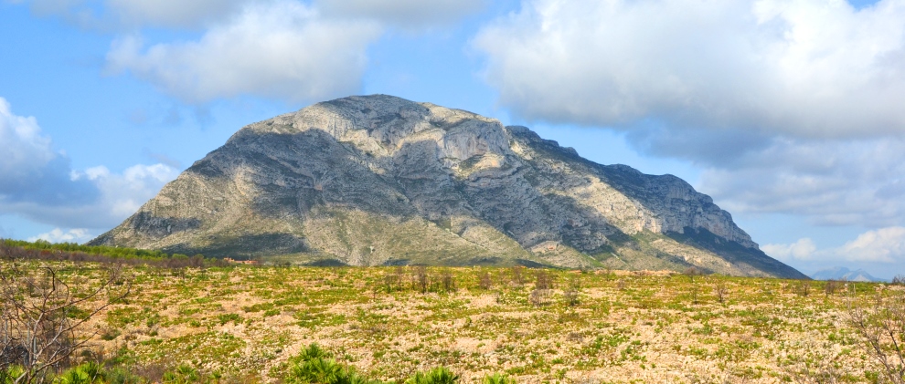
As the hulk of Montgó gets ever closer, the track continues across the flat plateau for some 700m until the trail forks; the route follows the right-hand option, marked with a wooden signpost “Montgo” and the usual white-and-yellow painted markings. The path passes through the undergrowth before starting to climb towards the final leg – the summit path to the top of the mountain of Montgó.
The wide and comfortable track ends at a large wooden information board. It gets tougher from now on. A small sign indicates the way to a summit, a narrow, rocky path that climbs steeply through the undergrowth. As the route climbs, don’t forget to look behind as the plateau opens up all the way down to the lighthouse of Cabo de San Antonio.
The path zig-zags up the eastern face of Montgó before passing below the Penya Roja, a red crag of rock that serves as a decent place to stop, take in some fuel and admire the view to east. After an hour or so of climbing the path apparently ends with stunning views over Jávea, its wide bay and the fertile plain. The final stretch to the summit is effectively a ridge scramble; look out for the white-and-yellow markings painted on rocks at intervals.
At the top of the ridge, a path hugs the cliff as it passes above an almost vertical drop down to the villas below, not one for those with a nervous regard of heights! And with a final scramble through a narrow cut in the rock, the summit is finally reached. Montgó is 753m above sea level and, on a clear day, the view is stunning in all directions. To the east, the headland of Cabo de San Antonio points towards the island of Ibiza on the horizon; to the south is the Peñon de Ifach (Calpe Rock), the Sierra Bernia and the Morro de Toix; to the west, the Col de Rates, the Sierra de Aitana and the Val de Laguart; and to the north, the gulf of Oliva and Cullera stretches up towards the city of Valencia.
Congratulate yourself for reaching the summit by the long way round. Now all that remains is to get back down again.