Heavy Rain and Thunderstorms on the Horizon for the Marina Alta
AEMET has issued a yellow alert for the region, with forecasters warning of intense downpours, thunder, and the potential for a classic ‘gota fría’ over the coming days.

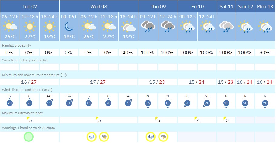
The Spanish state weather agency AEMET has issued a yellow-level alert for the potential for heavy rain and thunderstorms across the Marina Alta. The warning comes into effect on Wednesday evening and will remain active at least until midday on Thursday 9th October 9th, a bank holiday in the Comunidad Valenciana. Forecasters say there’s a 40–70% chance of intense rainfall, with showers capable of dumping up to 30mm of rain in just one hour, and as much as 60mm over 12 hours.
The University of Alicante’s Climate Laboratory has already sounded the alarm, noting that the region is on the brink of another episode of locally heavy Mediterranean rainfall. They expect the unsettled weather to begin Wednesday evening and potentially linger through the weekend.
Meteorologists say this is a classic setup for the area: a high-pressure system moving toward the British Isles will push easterly winds across the sea, while a trough of cold air slides along its southern edge from the Mediterranean. Add unstable air higher up and a warm sea, and you’ve got the ingredients for intense rain. They add that some models are predicting local rainfall totals of 100–200 litres per square metre, especially around the southern Gulf of Valencia and near Cabo de la Nao.
However, it should be remembered that a warning does not mean the worst-case scenario will definitely happen, it’s about potential. Whether the trough eventually breaks away and forms a DANA, or gota fría, will only become clear as the system develops.
That said, it’s a good idea to take simple precautions. Bring in anything from your balcony or garden that could be blown around, check that drains and gutters are clear, and make sure your home is ready for heavy showers. A little preparation now can prevent a lot of stress later.
What does a yellow-level alert mean?
The risk is low, but vulnerable people and property in exposed areas may still experience some impacts. Stay alert and keep up to date with the latest weather forecasts. Moderate damage to people and property is possible, particularly in areas susceptible to the adverse weather phenomenon.
What is a DANA?
A DANA – short for Depresión Aislada en Niveles Altos (Isolated High-Level Depression) – is a weather phenomenon that happens when a pocket of cold air gets trapped high up in the atmosphere, separate from the usual jet stream flow. This trapped cold air can linger over a region, and when it meets warm, moist air near the surface – especially over the Mediterranean – it creates a volatile mix.
The result? Sudden, intense storms. These can bring torrential rain, flash flooding, and strong winds, often in a very short period of time. DANAs are most common in late summer and autumn, when the sea is still warm and can fuel these storms with extra moisture and energy.
Some DANAs bring beneficial rain to drought-stricken areas, especially when the precipitation is steady and spread out. Others, however, can unleash destructive floods in a matter of hours. So while not inherently dangerous, their potential for harm is significant when conditions align unfavorably.
Be Prepared!
To prepare for a potential DANA, it’s important to stay informed through official weather updates from sources like AEMET or Meteoalarm, especially as forecasts evolve. Make sure your property is secure by clearing drains and checking for loose fixtures, and consider moving valuables away from flood-prone areas, including important documentation, especially identification and insurance paperwork. Have basic emergency supplies ready, including water, food, flashlights, and essential medications. Avoid unnecessary travel during alerts and know alternative routes in case of road closures. If you live in a vulnerable area or know someone who does, check in and make sure they’re aware of the situation. Pets should also be sheltered and provided for. Finally, keep monitoring the forecast models closely, as a DANA can shift quickly and dramatically alter the expected impact.