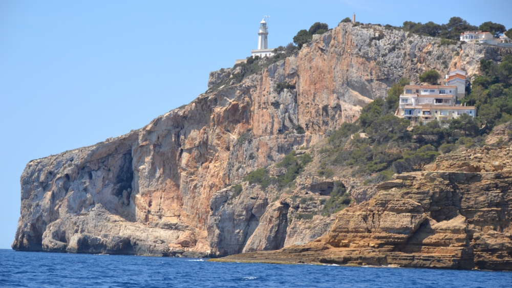
At the far eastern edge of Spain, where the land finally yields to the immensity of the Mediterranean, a pale limestone promontory juts boldly into the blue. Cabo de la Nao is no gentle shoreline. It’s a place of reckoning, where rock meets sea in a clash of elements, and time seems to pause in the salt-laced air.
This dramatic headland, carved by centuries of wind and wave, anchors one of the most iconic viewpoints in the Marina Alta. As part of the official Miradores network, it offers sweeping vistas that stretch from the cliffs of Moraira to the distant silhouette of Ibiza on a clear day. Nearby stands the Cabo de la Nao lighthouse, a sentinel since 1928, whose beam still guides vessels through these storied waters.
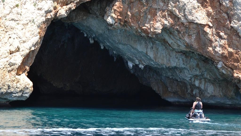
Below the cliffs, hidden from casual view, lies the Cova dels Orguens, a vast sea cave whispered about in local lore and admired by divers for its cathedral-like interior. Whether you arrive for the views, the history, or the elemental thrill of standing at the edge of the continent, Cabo de la Nao delivers a sensory encounter with nature at its most uncompromising.
The Viewpoint
The highest point of Cabo de la Nao rises to 117 metres above sea level, a crown of jagged stone and wind-swept scrub, and it is one of Xàbia’s network of stunning viewpoints. Reaching the viewpoint itself is no casual stroll. There is no established path and visitors must pick their way through sharp limestone outcrops and uneven terrain, a trip that demands care and sturdy shoes. But the effort is worth it. The vast Mediterranean stretches out as far as the eye can see. On clear mornings, the island of Ibiza shimmers faintly on the horizon, suspended between sea and sky, a distant echo of the cape’s enduring reach.
The Microreserva de Flora “Cap de la Nau” is a protected botanical enclave perched on the limestone cliffs of the headland. Established by the Generalitat Valenciana, this micro-reserve safeguards a unique assemblage of Mediterranean flora adapted to the harsh, salt-laden winds and sun-scorched rock faces of the headland. Among its most notable species are endemic and endangered plants such as Pine-Scented Germander and the Ifach Catchfly, which cling to the crags in defiance of erosion and exposure. The reserve plays a vital role in regional biodiversity conservation, serving as both a scientific reference point and a living archive of coastal plant communities and it can be observed at a respectful distance from the viewpoint, reminding visitors that even in the most rugged landscapes, delicate life persists.
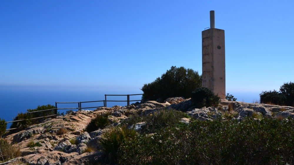
At the highest point of the headland, a concrete pillar stands quietly among the rocks. This vértice geodésico, installed by the Instituto Geográfico Nacional (IGN), marks the cape’s exact coordinates – 38° 44′ 00.95912″ N, 0° 13′ 49.27934″ E – and a fixed point in Spain’s national surveying network. There are over 11,000 spread across the country, small concrete pillars or monoliths placed on elevated terrain such as peaks, towers, and ridges. Its placement on one of the easternmost points of the mainland is not just symbolic, it’s a literal anchor in the national mapping grid. From this vantage point, surveyors historically calculated distances to other coastal and inland markers, contributing to the accurate rendering of Spain’s topography.
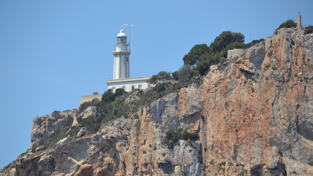
The Lighthouse
The Faro de Cabo de la Nao has kept silent watch since 1928. Its white tower, perched high above the waves, casts a beam nearly 23 nautical miles across the water, a rhythm of light that has guided generations of sailors through darkness and storm. But its journey to illumination was long and arduous. Although construction was ordered in 1902 and auctioned in 1914 for 68,212 pesetas, the light did not shine until May 26th 1928. The delay was due to the cape’s difficult topography, which required the building of a road to transport materials. The sprawling estate that we see now did not exist, the headland was remote and windswept. That winding route, connecting the site to the Duanes de la Mar neighbourhood, began in 1923 and proved crucial to the lighthouse’s completion. Curiously, Cabo de la Nao became one of the last lighthouses to enter service in the province of Alicante.
Its role in maritime safety didn’t end with its beam. In the mid-20th century, the lighthouse became one of the most important radio beacons on Spain’s eastern coast. Alongside the Islas Columbretes, it introduced a pioneering system of radio wave signalling. Lighthouse keepers, no longer just guardians of the flame, became operators of acoustic and electromagnetic guidance. The radio beacon emitted distinct signals, especially useful during dense fog when the light was obscured. Working with the Decca system, it produced characteristic beeps that sailors could detect with onboard receivers. Each lighthouse had its own identifying signal, followed by a series of waves that allowed ships to triangulate their position with precision. Cabo de la Nao’s beacon wasn’t just a guide, it was a technological leap, integrating light, sound, and radio to ensure safe passage through one of the Mediterranean’s busiest corridors.
However, the cape’s legacy in communications began even earlier than the lighthouse. On December 29th 1903, engineer Julio Cervera Baviera achieved wireless telegraphic contact between Cabo de la Nao and Ibiza, one of Spain’s earliest triumphs in radio communication. Working in parallel to Italian physicist Guglielmo Marconi, a pioneer in wireless telegraphy, Cervera had chosen the cape for its clear line-of-sight to the Balearic Islands. After surveying the coast in 1902, he rejected Cap de Sant Antoni in favour of Cabo de la Nao’s superior conditions. Construction began that April, with a 60-metre wooden mast, built without metal nails, rising from the cliff’s edge. From this structure, electromagnetic signals leapt across 96 kilometres of open sea to Cabo Pelado in Ibiza, where a receiving station stood in Sant Josep de Sa Talaia. According to Las Provincias, Cervera was soon tasked with replicating the feat in Ceuta and Melilla, underscoring the strategic importance of his work. From submarine cables to radio waves, Xàbia had become a frontier of communication, its cliffs not just scenic, but signal-bearing.
Cova dels Òrguens
Beneath the cape lies the Cova dels Òrguens—a spectacular sea cave sculpted by water erosion over centuries and one of the largest in Spain with a central chamber over 46 metres height. Surrounded by coves and islets, the cave is known not only for its geological grandeur but also for its cinematic allure: it served as a filming location for several productions, including Uncharted, the recent adventure blockbuster starring Tom Holland.
But its significance runs deeper than pop culture. The cave was first described in detail by Valencian naturalist Antonio José Cavanilles in the late 18th century, who marvelled at its vast chambers and organ-like rock formations. His pioneering studies of the region’s natural history helped shape early scientific understanding of the Mediterranean coast. Today, his legacy is quietly honoured in the port area of Xàbia, where a road bears his name – Avinguda del Botanic Cavanilles – linking the modern town to its scientific past.
These days, even though it can only be reached by sea, it has become a magnet for adventure tourism, drawing crowds during peak summer months, its dramatic scale and cathedral-like acoustics making it a social media sensation. In response, the local council and tour operators recently coordinated efforts to limit group sizes, enforce safety gear requirements, and discourage entry during rough sea conditions, so guided excursions remain the safest and most responsible way to experience this extraordinary sea cave.
Urbanisation
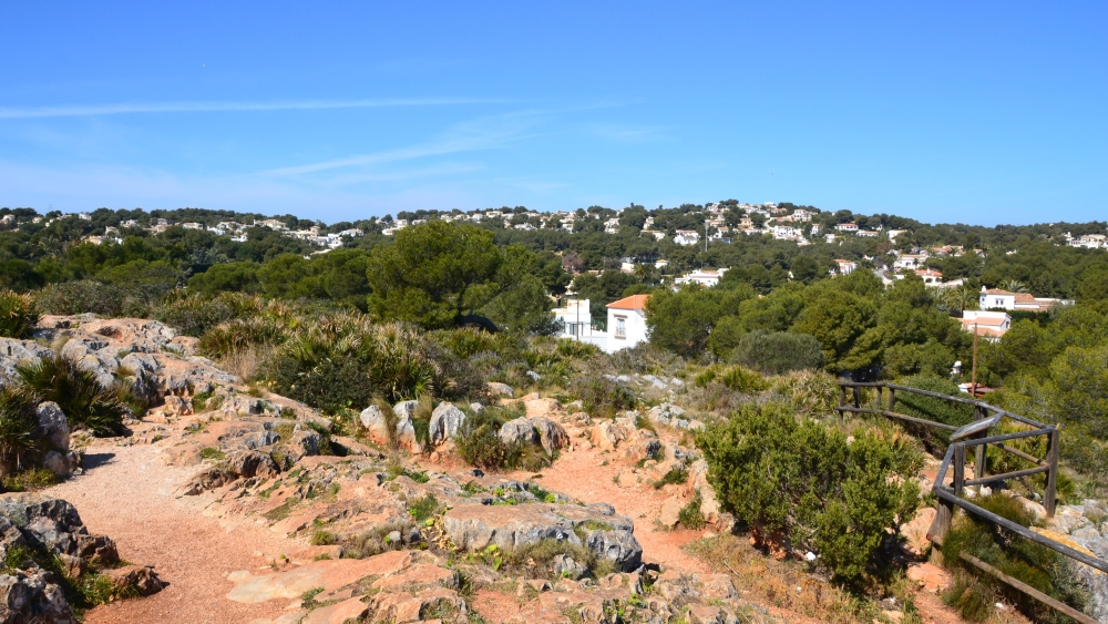
Despite the remoteness of the tip of the headland, the plateau behind the cliffs tells a more modern story. In residential zones like Balcón al Mar and La Guardia, the wild terrain has been steadily reshaped into a mosaic of villas, winding streets, and landscaped gardens. What began as a quiet retreat in the 1980s has evolved into a thriving international enclave, home to residents from the UK, Germany, France, Belgium, and the Netherlands. The transformation is subtle but unmistakable, nature’s edge softened by architecture, and silence replaced by the rhythm of year-round life.
Yet somehow, when you stand at the edge of the headland, the illusion of solitude remains intact. The wind roars. The light blinds. The sea speaks. Cabo de la Nao drowns out the signs of habitation, reminding every visitor that this is not a place for recreation, it is a place for reflection. Come at dawn or sunset, when the cliffs burn gold and the sea deepens to cobalt, and you’ll understand why sailors, artists, and dreamers have always been drawn here, not to conquer it, but to be humbled by it.
Sources:
Las Provincias, January 1, 1903 – Report on Julio Cervera’s wireless telegraphy achievement.
Instituto Geográfico Nacional (IGN) – Information on vértices geodésicos and national cartography.
Geamap.com – interactive map of Spain’s geodetic network.
Spanish Lighthouse Authority (Puertos del Estado) – Historical data on the Cabo de la Nao lighthouse.
Xàbia Tourism Office – Visitor guidelines and access restrictions for Cova dels Òrguens.
Javea.com – general information and context.
Maritime navigation archives – Details on Decca radio beacon systems and lighthouse signalling.