AEMET advises of possible cold snap this weekend
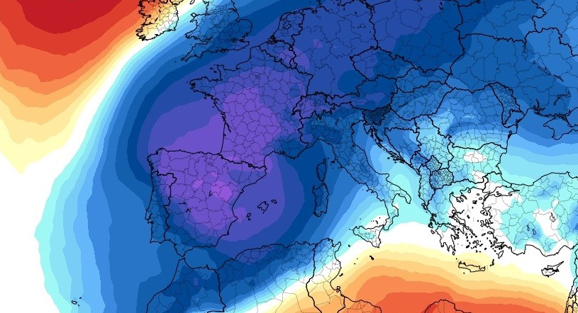
A very large mass of polar air moving south across much of the continent will result in a very significant drop in temperatures and the possibility of rainfall across our area.
Monday 15th March 2021 | MIKE SMITH
The state meteorological agency AEMET has issued information regarding the potential for cold snap which will affect much of Spain this weekend, the so-called “Puente de San José”.
From Thursday, a very large mass of polar air moving south across much of the continent will result in a very significant drop in temperatures (as much as 10°c below average in many places, including the Valencian region) and the possibility of heavy snowfall across the country (Philomena 2?), although it isn’t certain and is totally dependent of the evolution of the air mass as it moves down from the north.
The AEMET statement reads:
As of Wednesday the 17th, a progressive invasion of cold air at height accompanied by surface winds from the north and northeast will give way to a gradual return of winter conditions in much of the Peninsula and in the Balearic Islands.
This situation will manifest itself with intense winds from the north and northeast and with a considerable drop in temperatures, especially at night, with the sensation of cold and unpleasant weather in the northern half of the peninsula and in the Balearic Islands. A storm surge is also expected in the Strait of Gibraltar, the Alboran Sea and southern Andalusia.
Starting Thursday, rainfall is also expected to spread to many parts of the Peninsula and the Balearic Islands. In the case of the Mediterranean and Cantabrian watersheds, rainfall is likely to be strong and persistent, especially in areas of the southeast of the peninsula.
Snowfall will occur not only in mountain areas but also at unusually low elevations in the interior of the peninsula. Frosts are also expected in large areas of the northern half of the peninsula, which will be intense in moorlands and high areas.
This situation will continue throughout the San José long weekend, anticipating that it will begin to diminish on Monday 22.
Due to the uncertainty, it is very risky, for the moment, to specify more precisely the degree of adversity of this situation, so it is recommended to be aware of updates.
Information Source
AEMET Agencia Estatal de Meteorología