What is a heatwave in Spain?
The first official heatwave of the summer is expected to affect most of the country from Wednesday.
Monday 9th August 2021 – MIKE SMITH
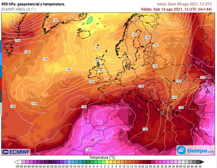
It has now been confirmed that Spain can expect the first official heatwave of the summer from this Wednesday 11th after models suggest with some confidence that a burst of very hot air from North Africa will affect almost the entire Iberian Peninsula and the Balearic archipelago, resulting in temperatures as high as 48°c which could be experienced in the Andalusian capitals of Córdoba and Sevilla whilst the nights on the Mediterranean coast could become quite suffocating.
So what is a heatwave in Spain? First of all, it shouldn’t be confused with the normal heat of summer. Spain is a hot country and that’s why millions of northern Europeans swarm to its renowned coasts each year, even during a pandemic, to enjoy a sun-drenched holiday on the beach. Nor should it be confused with the brief but intense high temperatures that we have experienced in the past few weeks, very hot periods that have lasted 24 to 48 hours, as a thermal roller coaster of peaks and troughs has swept continuously across the country.
A heatwave in Spain is an episode of very high temperatures that lasts for at least three consecutive days during which the maximum thermometer reading matches or exceeds the “threshold temperature” for that station. For example, in northern Alicante, that threshold is 37.9°c. If you venture north to, say, the north-western tip of Spain in Galicia, it is 29.2°c whilst heading south to Sevilla, it is 41.2°c. If the recorded temperatures exceed those thresholds for three days or more in 10% of the weather stations of the region, the episode is considered to have been a heatwave.
Clearly, in most cases, they can only be considered as such post-episode, but sometimes the conditions exist that make it quite obvious that a heatwave is expected, such as the models identifying the development of such a blast of hot air for later this week, as can be seen in the image below, which is for this Saturday 14th August.
One thing to consider is that the location of Xàbia is such that we are unlikely to experience the very high day-time temperatures that will have to be endured just a few kilometres inland; for example, the forecast for Pego for this weekend is that maximum temperatures could reach as high as 43°c, several degrees higher than Xàbia. However, it is expected that the sea will warm up quite a bit.
What it can mean for us here on the coast is that night-time minimum temperatures will be higher than normal – the average night-time low has been around 18°c this summer – and the weekend could see them stay as high as 24°c-25°c in many places overnight, which the weather experts have already described as a “suffocating” experience.
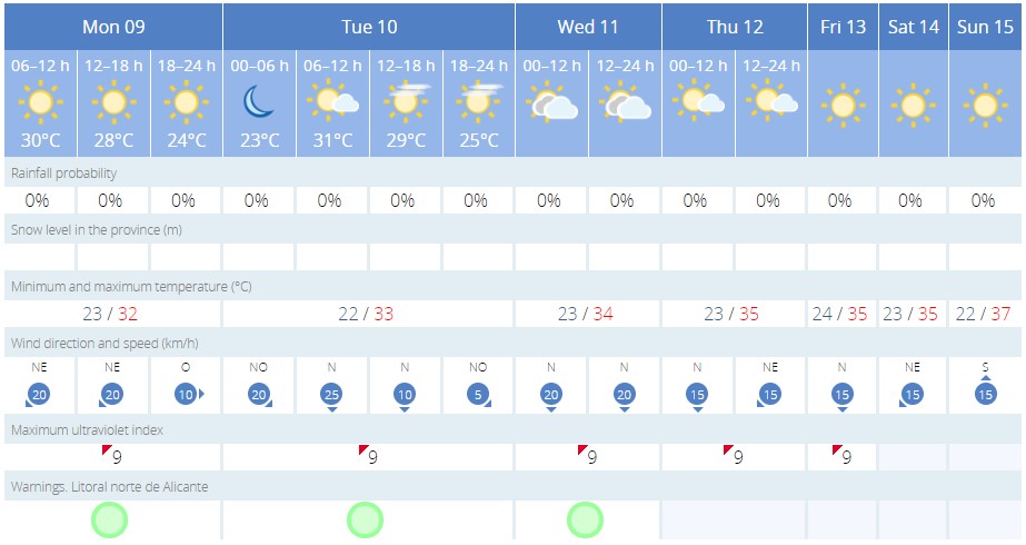
This Week’s Forecast for XÀBIA
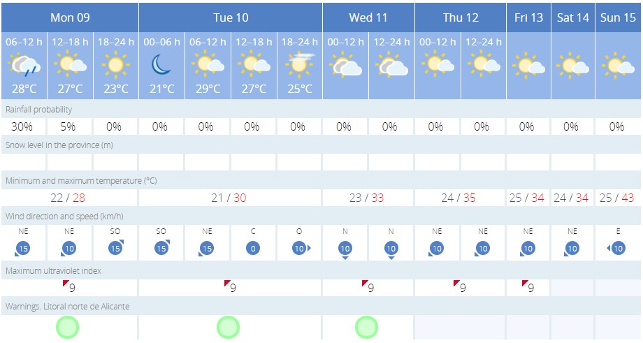
This Week’s Forecast for PEGO
What is in no doubt is that it’s going to be very hot, quite possibly the hottest few days of the summer, so we have a few tips of beating the heat.
Tips for Beating the Heat
- Stay hydrated. Water will keep your body cool and should be drunk even if you’re not feeling thirsty. Steer clear of sugary soft drinks which actually reduce your body’s ability to store water. In addition, alcohol, coffee and other caffeinated drinks should be avoided as they are all natural diuretics.
- Stay out of the sun. Avoid activities in the middle of the day and try to limit exposure to the sun between 10.00am and 4.00pm. Use the right sunscreen protection when outside for a long duration – SP30 would be the best option – and reapply often, especially if you have been swimming or sweat a lot.
- Stay in the shade. If you are outside for a long time during the hottest part of the day, try and use any shade as much as possible. Whilst the actual air temperature isn’t going to reduce, sitting out of the sun can make it feel a lot cooler, especially if there is a breeze.
- Spray water on your skin. Not everyone has the luxury of jumping into a swimming pool to keep cool but you can fill a spray bottle with water and keep it in the fridge so that when you feel like you’re overheating, you can spray a fine mist of cold water over your face and body to cool down.
- Dress to stay cool. Light, loose-fitting clothes will help you to keep cool. Cotton and linen clothes are better, synthetic clothing tend to trap moisture, such as sweat, and stick to your body, making you feel quite uncomfortable. Make sure your head is covered when in direct sunlight and a wide-brimmed hat that covers not just the top of your head but also your ears and back of your neck is the best option; baseball caps are not.
- Close curtains and blinds. The natural thing to do when it’s a beautiful sunny day is to open all the windows and doors to let in the light and the breeze. However, this doesn’t stop the sun’s heat from entering the house and it is recommended to close curtains and blinds during the hottest part of the day to keep that temperature down.
- Use fans to cool down. Fans can help you keep cool by continuously circulating the air in your home or office. Placing a bowl of cold water in front of the fan can help to reduce the temperatures, a home-made ‘swamp cooler’, but this won’t work if it is humid too. Air conditioning can ramp up the electricity bills but using it efficiently and in the areas where you spend most of the time will help improve comfort in a hot house without adding too much to the monthly invoice. Failing that, visit public buildings that have air conditioning such as the library, or browse a little longer in the freezer section of the local supermarket.