UPDATE: AEMET warns of potential for heavy rain and strong winds on Friday
Forecasts suggests there will be a significant change in the weather at the end of this week, including moderate rainfall, which could be heavy at times, as well as a significant drop in temperatures,
Updated: Thursday 3rd March 2022 – Mike Smith
Source: AEMET Meteorological Warning / UA Climate Laboratory / MeteoXabia
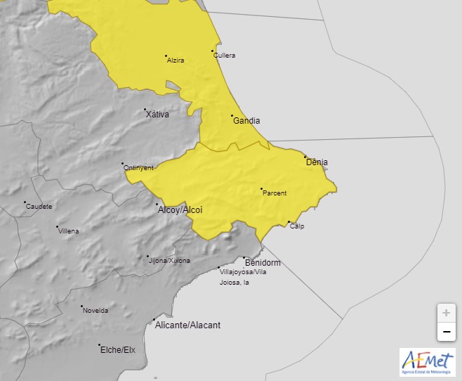
The state meteorological agency AEMET has activated a YELLOW alert risk warning for the potential for heavy rain, storms, strong winds and heavy seas this Friday 3rd March throughout the Marina Alta region. The warning suggests that some areas of the region could see precipitation rates of 20mm per hour and 60mm in 12 hours whilst wind gusts could reach up to 70 km/h, resulting in stormy seas with three metre waves pushed by Force 7 nort-westerly winds. This special notice is valid from midnight on Thursday night and will remain active until 6.00pm on Friday.
The University of Alicante’s Climate Laboratory says that a very complex weather system is likely to develop due to the evolution of a storm in the Mediterranean which will not only result in heavy rain in localized places – as much as 100 litres/sqm may fall in some areas – but also strong gusts of wind at times. Although the trajectory of the storm is still uncertain, it is very likely that our region will experience moderate rainfall with locally intense downpours; the former will be much welcomed by the mountains and countryside which has not seen any significant rainfall since last November. However, the Laboratory considers that there will not be any persistent torrential rain but rather that there will be locally intense showers.
MeteoXàbia considers that the indications are that the storm will form off the southern coast of the province of Alicante which means that we probably won’t be as affected so much by intense rainfall as other places but that the rainfall could be quite persistent for a few hours during Friday morning, possibly heavy at times, whilst it will become drier during the afternoon.
Note: The alert doesn’t mean that these conditions are definitely going to affect us but that the models are showing that there is a good chance that they may do so so it’s best to be prepared.
Prepare for the Worst
- Check guttering and drains. They should be clear of leaves and other debris to allow the rainwater to flow away easily. Take a look at the drains in the street in front of your property. It’s the council’s job to keep them clear but checking them yourself before the arrival of heavy rain can help protect your home.
- Prepare the terrace and garden. Cover up and secure patio furniture. Bring in anything that is likely to be blown around the garden and cause damage.
- Protect valuables. If you live in an area that is liable to flooding, you might want to consider gathering together any valuable or sentimental items and store them in a safe area of the house – not the basement – during the periods of heavy rain. Just in case. Material items can be replaced, memories can’t.
- Avoid driving. During periods of heavy rain, it is best to stay put, wherever you are, and avoid driving in low-lying areas and zones where water is likely to collect. Don’t attempt to cross the river if the water is flowing as it may be deeper and stronger than it appears; it only takes a few centimetres of fast flowing water to dislodge a vehicle. If the heavy rain causes poor visibility whilst driving, stop and wait until it passes.